Monday, September 30, 2024

Into the Mountains (#8 Montana, #7 Idaho)

We had hot but nice weather in North Dakota but when we awoke, it was smoky and hazy.  There were also clouds over Yellowstone and I started to second guess our route.  We would fly from Dickinson to Billings Montana to tank up and then on to Idaho falls.  The path to Idaho Falls had some big mountains to cross, some above 12,000 feet.  Our plan was to fly Billings to Cody and then West along Highway 14 and through Sylvan Pass.

My concerns included clouds/obscured mountains, low visibility and winds/turbulence.  It looked like we might have issues but regardless of what we ultimatly did, we would stop in Billins so off we went.  Departing Dickinson, we had haze with 3-4 mile visibility.  We went IFR and were soon cruising in a brownish cloud.  We were able to get the visual approach at Billings and picked up the runway about 6 miles out the visibility was getting better but not as good as I wanted.  

We had a quick turn at a nice FBO.  They stocked us with water and Dot’s pretzels, a local brand, and they insisted we take several bags.  They were fast and efficient and we were soon heading to Twin Falls Idaho.  The weather reports on both sides of the mountains were better with improved visibility and no clouds so we pressed on even though the conditions were only marginal in Billings.  We initially climbed to 8500.  Though VFR we had flight following the entire way and Salt Lake Center kept a close watch on us.  Approaching Cody the visibility got better and I stopped focussing on backup plans and started executing our current one. We step climbed to 10,500 and started to track down Highway 14.

I have a new addition for the plane, an oxygen generator to provide supplemental oxygen.  We were not going to be at altitudes that required O2 by regulation but more O2 is better than less.  We continued to step climb to 12,500 which put us above most of the terrain.  We have terrain awareness that lets us monitor our position relative to terrain and we were flying a pre planned route to avoid terrain but having extra awareness is always good.

I have flown at 12,500 before without O2 and was fine but both CC and I felt the extra O2 made us more alert.  As we entered the valley to transition the mountains, the visibility went from bad to great.  We were soon seeing 60 plus miles and could clearly see all the terrain.  We could even see the Grand Tetons off in the distance.  Going to 12,500 made it much easier.  The pass we had planned to use was 8,537 feet so we had plenty of clearance.  After we cleared the mountains, we crossed Yellowstone lake and had a smooth ride all the way to Idaho Falls.

Our FBO at this stop was Aeromark, they brought our car out and fueled us as we sorted our junk and then it was off to the Falls in Idaho Falls.  They had been altered by the engineers but they were cute.  Then it was off to Rexburg where we found our hotel room not ready.  The excuse was that the coming Friday was move in day for the local college.  That made little sense but I felt further inquiry was futile.  We continued on our way to visit Mesa Falls.  The drive up started flat but ended up in the foothills.  


Arriving we went to pay our $5 entry fee and found out our park pass covered us.  Another score for the America the Beautiful Pass.  The waterfalls were big and impressive.  The upper falls were right in front of us but they were angled a bit which made the view a bit from the side.  The lower falls had a great straight on view but you had to observe from a distance.  

On the way back we enjoyed some overlooks and stopped by the Warm River which was not warm by my standards.  The Terrain was very scenic and we really enjoyed our drive.  Today we knocked off 2 more states.  We did not sightsee Montana but we will when we visit Yellowstone, stay tuned.  We are down to 6 states left, getting close to done.


Sunday, September 29, 2024

Hot Hot Hot (#9 North Dakota)


We woke up to cool fall temperatures in Tennessee which was refreshing after our Florida summer.  With the time change we had what felt like a 9 AM departure.  There were 1021 miles to cover; it was one of those trips that can be done in 2 or 3 hops, we have plenty of range but I went with 3.  We mostly went direct but made a small detour South of St. Louis to avoid the Bravo airspace.  

Our first stop was K89, Macon-Fower Memorial Airport in Macon Missouri, a gem of a fuel stop.  As I shut down at the pump, we were met by Larry who got the hose out and helped get us fueled.    The FBO was clean and they offered us water, soda, and snacks.  We left with one water bottle and two bags of chips.  Our second hop was a quick one and we dropped into CKP, Cherokee County Regional Airport in Cherokee, Iowa.  I knew it would be unattended and it was pretty deserted.  The FBO was open as promised and the facilities were ok.  The fuel pump was fast which is always a plus in my book, other than that, nothing special.

This was the last of cheap gas for a while so we topped off before making the hop to Dickinson, ND.  We had previously seen South Dakota on an earlier trip. With a combined population of 1.7 million, you have to wonder, did we need both?  Why not just Dakota.  Well it was a possibility but back in the late 1890s it was all about stacking the Senate so we have both.  Not a lot has changed in the last 135 years.  

Our arrival into Dickinson was easy, 7300 feet of runway and the line guy was out to meet us.  Our rental car was ready so it was almost all good.  It was a fine car but it was the dirtiest car I have ever rented, but only the outside.  The inside was OK.  We had flown around 1400 nm in 8.4 hours with 6 hours in the air.  Overall we averaged 167 knots which was pretty good considering the constant headwinds.  Average TAS in cruise was closer to 185.

We had come to Dickinson to visit the Theodore Roosevelt National Park.  It is about 30 minutes West.  Monday morning bright and early we were off to visit the North Dakota Badlands.  We had seen the South Dakota ones, they are similar in that you have the Buttes with the obvious layers but different in that they are more integrated with the grasslands while the Southern ones are more rocky.

The park normally has a loop road but it was partially closed for construction.  This made it an in and out drive instead.  We decided to drive to the end of the road and then work our way back.  We mostly did that but did stop along the way near the end.  The big surprise was the weather.  We had left Florida to enjoy the cooler temperatures of Fall up North.  Back home it was muggy and mid 80s.  Dickinson was forecast to be 93 and it did not disappoint.


The morning had started cool in the 60s and we enjoyed the fresh start.  We did some short hikes and saw bison, wild horses, a snake, lots of Prairie dogs and I saw a bunny hop by.  As the morning progressed the temperatures rose but funny thing, 93 in North Dakota was not that hot.  The low humidity and breeze made it quite bearable.  

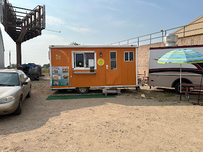
We finished the South portion of the park and drove the hour North to see the North part.  Less animals but more views.  After that it was back to town to pick up dinner.  I had found a Taco truck.  The owner was interesting but there had been a run on Mexican food and by the time we arrived he had sold out of many items.  No Guac, no rice, no chips!!!  In the end we had Tacos and a Quesadilla.  

Food was good but not not amazing.  Overall North Dakota was a nice place to visit but can’t imagine sticking around for when the snow comes.  I spent a good amount of time looking at the weather and planning my flight for Tuesday.  This was potentially one of the most difficult segments of the trip.


Saturday, September 28, 2024

David and CCs Big Adventure


We had completed 39 states as of 2023 but the first half of 2024 we made no progress.  Lots of reasons but mainly we had the far away ones left and the best time to visit them is either April/May or September/October.  Sam graduated in May and we were busy in April so that meant pushing off our big travel until September.


The Baron is often described as an all weather aircraft but the reality is that it is a most weather aircraft.  Having radar, lots of redundancy and de-ice helps a lot but it can’t handle everything safely.  Our initial plan was to head out Sunday at 8 AM to get up to North Dakota by around 4PM.  In a perfect world it was a doable plan but after a dry spell in Northern Florida we were beset by a constant deluge with a front sitting on top of us for days.  Little did we know the people back home would start building arcs after we left and a Huriicane would slide through for good measure.


After getting 5+ inches of rain Wednesday before departure, I made the call to leave early.  The problem was that the FBO in North Dakota closes at 5 PM and our rental car was being left there.  Being late would have cascading effects.  If we had early storms Sunday morning, it was possible a delayed departure would blow the plan.  Leaving a day early would get us 2.5 hours ahead and move us to clear weather on Sunday.  On Saturday we could be very flexible on the departure.  


It was decided and after some searching I chose Tullahoma, TN.  It was big enough to have everything we needed and small enough to get in and out easily. As a bonus, it had good fuel prices and a Beech Museum.  When I checked the weather at 7:30 AM there were storms in our path and our home base was 600 Broken.  It was forecast to improve and the storms were moving quickly to the East.  

When I put the bags in the car I was surprised by a high broken layer and partial blue sky which looked pretty good.   I had a lot to load.  3 weeks on the road meant lots of clothes.  In the end we had 10 bags totaling 160 pounds, crazy.  Clothes took 2 medium duffels and a small overnight bag. We had a toiletries bag, camera bag, flight bag, hiking bag, snack bag, a laptop bag and CCs purse.  It adds up fast….


Preflight was smooth, I had set the plane up earlier in the week and the Baron has tons of room so it swallowed our bags easily.  At full fuel load we would be at 5300 pounds and in the mountains we would back off gas to allow for departures as light as 4904 pounds.  


Our departure was into 900 overcast which was smooth and easy.  Tops were around 1900 so we were soon on top fighting headwinds.  I expect all Westbound legs will be into strong winds and coming home light headwinds.  The morning storms had mostly moved out of our way but about 80 miles out the XM radar was showing lots of yellow.  This was a day for the active radar as we were soon swallowed by a layer and I started plotting our route.


Getting closer I could see a few areas of heavy rain on the active radar.  A quick request let us deviate to the West a few miles which put us on a new course that would avoid anything heavy.  We had some light sprinkles for around 10 minutes but soon cleared the weather and started to see blue skies.  


The direct route would have taken us over Atlanta which I knew was not going to fly so I had filed GRANT T294 HEFIN and surprisingly we got to fly just that.  Usually ATC vectors you even when you file the published bypass routes but today they must have been in a good mood.  The rest of the flight was uneventful and we made a bumpy approach to Tullahoma, TN.  Winds were 10 Gusting 21 and variable.  I had to work for it but the first landing of the trip was nice.

Pulling up to the FBO I found a space and headed in.  The nice folks got our fuel order and the price was less than online, a nice surprise.  They offered a ride to the Museum but we chose to walk the quarter mile.  It was 75 and a wonderful day with blue skies.  The Beech Heritage museum started as the Staggerwing Museum but then branched out to all Beech airplanes.  They have about 40 aircraft and it’s a nice stop.  It is also home to the annual Beech Party, a gathering of Beech Aircraft owners and all things Beech.  I have never been but it sounds fun.  You can actually taxi your plane to the museum but I thought it a bit silly to fire up the plane twice when I needed the exercise.

After seeing the museum, we walked back to the FBO.  On the way one of the people from the airport stopped to see if we needed a ride back to the FBO.  This was pretty typical, lots of friendly people.  Our initial plan was to Uber to our hotel but the FBO had offered to run us over and grab us in the morning.  While we were buying cool shirts at the gift shop, the museum manager told us her husband worked at the airport and to get the courtesy car and go see some sights.  When we got back to the FBO we inquired about the car and were given keys.  We decided food was top priority and headed out for burgers and fries.  


We took them back to the FBO and sat out and watched the sky divers and a local glider getting towed.  It was really nice to hang out under blue skies for a change.  After our burgers we went and borrowed the car again to go see a local waterfall.  Yes, long time readers will know that I am a big fan of falling water.  


Rutledge Falls were only about 20 minutes away, easy to find, lots of parking and a short trail to some really nice falls.  We stayed in the safe area though many people seemed like they wanted to hurt themselves by climbing the slippery rocks.  We watched the water for about 30 minutes and then headed back.  It was near the end of the day and they let us keep the car overnight.  Our Hotel was only 5 minutes away but this made it super easy.  Tullahoma earns Five Stars!!!!!


Friday, August 2, 2024

Weather Weather


I had a flight today to the Atlanta area and back.  I had thought looking at the forecasts it might be pretty easy with only scattered showers.  I was really wrong.  I woke up this morning to a line of storms forming across southern Georgia.  I thought they might dissapte by the time we left but they defied predictions and intensified.


I was not too concerned as there were gaps and the Eastern edge was not a big detour.  We departed in clear skies and were soon cruiding along and sizing up the line.  Things were changing pretty rapidly but most planes were sliding through over Hazelhurst, GA.  This was good for us as that was our direct course so we just cruised on up and and worked between one small cell to our left and some light rain to our right.

We were through pretty quickly and in person these were not very impressive storms.  Not that I wanted to fly in them but they were not very tall nor big.  

Our arrival into KPDK was a bit different than past trips.  I filed the WRGNZ3 arrival with the WRGNZ transition.   ATC let me fly it!!  In the past, just as we have gotten to WRGZN, they put me on vectors.  The other difference was that we had traffic ahead which required us to swing a bit North of the field and join final at around 3 miles.  It all worked and we soon touched down on 21L and taxied to the FBO.  We were there to visit our daughter and drop some stuff off.  After unloading and checking in we were picked up and headed off for food and visiting.

I looked at the storms and after we passed they started to fall apart.  I thought that was a good sign but around 1:30 I looked at the flight home and stuff was bubbling up everywhere.  We watched it for about and hour and then headed to the airport.  It was unclear what it would do but we figured we could at least get to Southern Georgia.

Our departure was easy but bumpy.  Heading up it was really hazy and the haze had not gotten better so while technically VFR, I was keeeping an eye on the instruments too.  Atlanta approach sent us East and climbed us to 9000 before sending us on our way.

The line of storms was blocking our return and we started making plans.  I initially asked for and was given direct Taylors VOR as there was a good size gap.  By the time we got closer the gap was shrinking and my vertical profile of the storm was showing tops at at least 40,000.  Even with a clear gap I could see through, did not want to mess with potential hail.  

We made the decision to invest 15 minutes of extra flying to be safer.  We updated our request to Valdosta and ATC was very accomodating.  This let us round the end of the line and stay upwind of the storms.  

Behind the line of storms the XM radar was showing lots of light rain.  Onboard radar showed just a little.  We slid around the line and then just had light sprinkles as we worked our way home.  The onboard radar gave us some good clues as to what deviations to request as it was hard to differentiate between haze and rain.

My last concern was whether we would have a storm at home.  That was the only weather forecast that held up.  There had been some sprinkles ealier but we arrived to high overcast and blue skies and soon had the plane away.    The detours and unfavorable winds added about 20 minutes extra but was well worth it to avoid the weather.  In the end it took a few extra minutes but we did go to Atlanta, spend 4.5 hours and get home in 9 hours total so the few extra minutes were not a big deal.


Friday, July 5, 2024

Fireworks

Fourth of  July means Fireworks!!!!!  I am sure there are rules against shooting explosives over you neighbors house but where I live, it seems to be more of a suggestion than a rule.  I have seen fireworks from a distance when flying and they always seemed a bit puny but I had never gotten up close.  Well not too close.  I had heard it was a good show so this year CC and I decided to have a look for ourselves.  Our plan was to cruise out to the beach and circle the show.  Our city used to do one big display but during COVID it was changed to several smaller ones.  This has actually worked well with more people being able to get to see a dsiplay closer to home and allowed us several options.


We headed out to the airport around dusk and were ready to depart about 10 minutes before the show.  This may sound like we were cutting it close but the show was 3 minutes away.  I departed and was handed off to departure where I picked up a code and wandered over to the Beach.  I went up to 1300' so as to provide some seperation with other traffic already circling.  No circling would imply some order, they were mulling.  I was going to need to work hard to avoid them as I was significantly faster than the 70-80 knots they were doing.  


I figured we would all be talking to approach because we were right up against an active squawk and talk TFR but no.  We had 3 planes talking to no one in no semblance of a pattern.  We did a few turns around but I was keeping the controller really busy calling traffic which we had in sight. I was busy lapping them and trying to guess what they would do next.  I decided it would be safer to see another set of fireworks so we cruised a few minutes over to the mall where we had our own private show.  After a few minutes there, we cruise over to the West bank to see that set.  The mall was a bit smaller but the river was as good as the beach.


We had both of these to ourselves so that was really nice.  We could also see the Downtown ones to the North.  Heading over I asked for a Navy JAX class D transition and approach said there was a blanket approval for the class D transitions but to stay off the runways...  We caught the finale on the West side which was right around 9:20.  There was one more show down in Saint Augustine at 9:30 so off we went.  It's amazing how fast you get around town at 150 mph.  Arriving, there was a sheriffs copter who was talking on the SGJ CTAF and he was already in a counterclockwise orbit.  We joined the circuit and watched a bit.  We then had another plane join and luckily she was talking too.  


Even with the talking she did not quite go where she said she would which meant some careful watching as we lapped here.  It was getting busy in the sky so we cruised back towards home.  While all the official fireworks were going off, there was a constant barrage of backyard stuff.  Some small but there was continuous stream of larger stuff, some going up a few hundred feet.  It was a great show and from above it looked like one continuous show across the city.  It was all fun and games untill we were landing where I had fireworks going off all around the airport.  Maybe they were not shot from the airport property but it looked like they were coming up feet from the fence. 


There was a layer of smoke drifting across final, visibility was still good but it looked ominous and with the flashes, it was all quite distracting.  We still managed to find the runway and have a safe but not as smooth as normal arrival.   Pictures are all courtesy of CC, I was way too busy flying to get any snapshots...