Saturday, June 19, 2021

Is it raining?


I woke up early today and decided to take a quick flight.  The weather looked gray but the clouds were high and it was not yet too hot.  Out West of town there was a line of rain showing on radar.  There was big rain with Claudette battering Mississippi and Alabama but just light stuff nearby.   It was a mix of green and yellow about 40 miles West so I went exploring.


The three sources of weather I have all use different color codes for different intensity.  Basically green, yellow, red, magenta signify rain in increasing intensity but the line between each is different for each display.  A good rule is avoid all red and magenta.  Green is fine on all scales and yellow depends.  On XM yellow  is usually fine and equates to dark green on ADSB.


Today as I approached the line, my active radar was painting it as mostly green aligning with the ADSB while the XM was showing more yellow.  The lightest green can often be just cloud without rain but today it was light rain.


I flew up to the first drops on the windshield.  Not wanting to beat up the paint, I turned around and headed home without exploring more.  It was another good lesson in interpreting the multitude of data sources.


As I type this, the current picture shows green above me but no rain.  Is it now wrong?  Probably not, it is likely raining up high but the rain is not reaching the ground but rather evaporating on the way down.

Thursday, June 17, 2021

A Dark and Stormy Night

I have been wanting to get night current again.  To carry passengers, the FAA mandates that you must have made 3 landings to a full stop in the preceding 60 days.  Day currency is easier, you have 90 days and the landings don't have to be to a full stop.  The other twist is that night does not begin until 1 hour after sunset.  Last night sunset was 8:30 PM and thus my landings had to be after 9:30 PM.


I had been looking for a good night, the last few had been really stormy or cloudy but yesterday it looked perfect.  The skies were mostly clear, just high clouds, the winds light and the storms were slowly dissipating.  I headed off to the airport early so I could do all my pre flight checks with good light.  Once the plane was ready, I visited with another pilot working on his plane and watched the storms that had built North of the field.


It was a nice show, the storms were about 40 North and mostly moving East.  You could see the lightning jumping out of the clouds in the twilight.  As the light faded I headed to the plane and fired up a bit after 9 PM.  Originally I was going to go to JAX for my first 2 landings.  They have a 10,000 runway which provides plenty of room to come to a complete stop and then take off.  The Storm location and the need to work around airline traffic inbound made me change my plans.


I would have gone to Cecil but the Notams had indicated the long runway was closed.  I chose St. Augustine which ended up being a good choice.  8,000 feet and the control tower closed at 9 PM so I did not have to ask permission for my practice.   Departing I headed South and then looped back North to see how the storms looked on the radar.  They had moved a bit closer so I kept an eye on them as I didn't want my return to be cut off.  The big picture looked ugly though, The South part of Florida was quite rainy.  


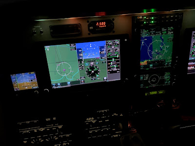
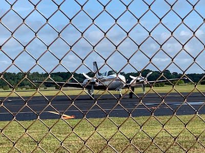
I flew South of St. Augustine to waste a bit of time as I was early but soon was on the downwind to land.  I had the airport to myself and this would be my first night landing in the Baron.  Downwind I reset the pilot controlled lighting so it would stay on for my landing, gear was confirmed down and I had set the visual approach into the GPS so I would have both lateral and vertical guidance in the dark.  The big displays and synthetic vision makes the approaches easy.  The Baron also has 2 landing lights and a taxi light which provides plenty of illumination.  St. Augustine has the new LED lighting which is really bright, almost too bright for my taste but would be nice on a foggy day.  After the second landing I headed back home.  


The winds on the ATIS were 240@10 so I was planning a 23 arrival.  Checking in with tower he said things were shifting and winds were 030@5, did I want 32.  I did and joined a long final for 32. While doing my landings I had seen the sky light up with the distant lighting.  Heading North I had an amazing light show of some pretty extreme lightning.  Now those towering storms were starting to impact my local weather.  The wind was still 240@20 up at 2000 but the outflow from the storms was reversing the winds down low.  At 3 miles out the tower advised me that the winds had shifted to 050@11 gusting 17.  


New plan, I was cleared to circle to 5.  I was watching the winds as I made my approach, expecting the wind shear. Going into a headwind is not a big issue as you gain some airspeed. Just as expected, at 200 feet the winds swapped from 10 knots tail to 10 knots head.  My touchdown was good and tower cleared me all the way down to 32 for the taxi in.  It had been a great night for practice but the weather was changing.  I put the plane away and later it poured but I was already safe at home.


Sunday, June 6, 2021

Thunderstorms

 I knew that there would be a chance of thunderstorms heading home from Beaufort.  The forecast was for widely scatter rain around home but nothing in South Carolina.  That was really wrong.  Getting the plane ready I could see a storm off the end of the runway and the radar showed several en-route.  I only had 2.5 hours of gas left so I had decided to make a quick stop in Georgia for gas before heading South into the building rain.  The storm below was off the departure end, I had already turned a bit left so as to avoid it.  


The initial flight over to Baxely, GA was easy.  There was some rain but it was widely scattered and easy to avoid.  I soon had my tanks topped which gave me over 8 hours of endurance (10 if I go really slow) so I was ready to try to get home.  Lots of gas means lots of choices.  The direct route was blocked by a line of storms stretching about 100 miles. This meant meant going around the top or bottom.  The storms were moving North but the Southerly route added a lot of miles so I chose the top and once off the ground checked in with center.  


Center was busy keeping everyone safe but not a lot of planes out.  I had debated going back VFR but wanted to climb up where I could hopefully see better and figured that it might be hard to stay VFR.  Checking in with center I was given my clearance and we agreed on a plan.  I headed East and started watching the weather.  I have decided that I like my active radar on my main screen with the XM weather on the primary GPS.  This way I can compare the two.  I was mostly watching the radar out to 40 miles with a +4 tilt.  This painted the weather well without ground clutter.  It quickly became apparent why I am getting to really like my radar.  The XM and live showed similar pictures but the XM was offset South.  The storms were moving North and while it was a good big picture, it was old and deceptive.


Getting near the coast I found a nice alley between the clouds and center was very accomodating on headings.  Combining my eyes with the live scan, I made my way through the building weather without getting wet.  Later I did get some rain flying under some light precip.  I was not in the clouds then, just raindrops falling on my plane.  Once crossing through the line and flying over to the coast I was in the clear with clouds above.  It looked like the afternoon sea breeze was keeping the weather inland.


Getting close to home things looked complicated.  The XM showed a storm on the airport but the radar showed that only light rain was falling.  I could see some heavy precip blocking about 180 degrees of the sky but I had a clear escape route if things did not continue as planned.  The last 5 miles were wet with a steady light rain culminating in a touchdown on a very wet runway.  The plus side was a perfectly smooth landing.  I did go back to the plane today and wiped off the dirt I knew the water had flung under the plane.  It was not as bad as I expected.


Overall, the radar gave me that extra advantage which let me navigate around some serious weather.  While I could have probably made it in my last plane, not sure I would have tried it because there were several times where I could not clearly see ahead and would have likely landed to wait it out.  The radar can't get you everywhere and you still can't go through heavy weather.  It does help you see and avoid it though. 

Saturday, June 5, 2021

In the box

 I woke up early Saturday to head off for more training.  I spent 15 hours with an instructor and another 10 for my initial transition training.  You learn a lot in the plane but there are many things we have to modify in practice because it would be too dangerous to practice for real.  Engine failures are at the top of this list.

Losing an engine in the first few seconds after liftoff  is a difficult test for any pilot.  In some situations the best outcome may be a bent airplane.  Thus we practice these events further from the ground.  In the simulator, we can safely practice all these scenarios.


The training was in Beaufort, SC so I had a nice flight up the coast and a smooth arrival at the airport.  Once down, I went to the lot and had instructions how to borrow one of the cars.  The training is just a few minutes down the road and I was soon completing the briefing with my instructor.


We went through the book work and procedures we were going to practice in the simulator or box.  While the simulator did a good job acting like a 58 Baron, it was not my exact equipment.  This made it harder in that the equipment was like what I had used years ago.  This was not a big issue in that mostly you are concerned with handling the emergencies.


Training started with basic flying, then instrument flying.  We progressed to stalls and VMC demonstrations and then it was off to engine out practice.  The first few were easy in that I was already 200 feet in the air.  The engine cut at 30 feet just as the gear was coming up was interesting but I followed the drill, kept control and slowly climbed away.   We then did single engine instrument approaches to minimums next, and added one with a go around.  A go around on one engine is not really a maneuver you want to do from a low level for real.  In the simulator you can risk it.


I asked for one additional scenario which was an engine failure at a high density altitude at full weight and high temperatures.  In this case you can't climb but if you have planned well you can fly the terrain to a lower elevation airport.


It was a 4 hour program and it went by fast.  We did a quick debrief and then I was headed back home.  That turned out to be the harder work for the day.