Tuesday, January 31, 2023

Foggy Nights

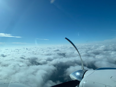
Monday I went for a night flight.  The weather at home was good, 4000 broken but off to the Northwest, the clouds were lower.  I filed an IFR plan to Homerville, GA and back home.  Just South of JAX I hit a cloud wall which is what I wanted, I have been building night experience and was expanding to night IFR.  I have very little actual IFR at night and this was some good practice weather.

Arriving in the Homerville area I set up for the GPS 32.  AWOS was calling for 3500 Overcast and though I turned up the runway lights, I could not see the field.  The reason was soon apparent, there was a lower layer between me and the field.  At the FAF, I could see the beacon winking at me through the clouds but no runway.  Minimums are 491' and the field is at 187' so you an go as low as 300 feet above ground level.  Given the conditions I set my minimums at 600 to give me some extra room and started down.  I was solid for most of the way but right at 600, poof the clouds parted and the runway was right ahead.

I executed the missed and I guess the AWOS was right as it was clear over the airport.  A valuable reminder that the weather over the airport is not always what you may get on the approach.


Tonight I went out again for some more practice.  There had been sea fog most of the day at the beach but the forecast was for good weather until after midnight.  As I was holding for departure, the chatter on the radio was the approaching fog.  Mayport was 400 and Fernandina was 300.  I launched but decided to stay close to home.  I spent a nice hour watching the fog slowly roll in.

It never quite got to the airport and a few hours later it still hasn't.  It did get within about a mile though so not wanting to risk having to divert I headed in at the end of my hour.  There was a cool breeze as I pushed the plane into the hangar but it was decidedly warmer at home.  Interesting weather and great training.

Wednesday, January 4, 2023

A line I wouldn't cross

I had planned to just drop by the plane to do some cleaning but when I arrived I took another look at the weather and couldn't resist the training opportunity.  Today was a perfect day to shoot approaches and practice with the radar.  There was a line of storms moving in and as I sat in the hangar it was about 130 miles out.

I was a bit low on gas, only 3 hours, so I decided to start with a practice approach and top off.  I headed to 28J and shot the GPS 27 through some bumpy clouds breaking out at 1600 for an easy arrival.  After topping off, I picked up my clearance on the ground and was quickly released.  My plan was to fly to OTK (Valdosta VOR) and then turn around and come home.  By the time I was back in the air, the storms had moved much closer to OTK so I wouldn't have to go as far to practice with the radar.

I have been very happy with the addition of onboard radar to my bag of tools and on several trips it has really made a difference and allowed us to travel through areas of convective weather safely.  Today was not one of those days.  Even though radar gives you the real time information to safely avoid severe weather, today there was no safe path to find.  It did provide some good practice though.


This was a significant line and was actually easy to image at 100 miles.  The physical horizon was 95 miles out at my 8000 foot altitude.  I started with a 0 tilt and you can see the ground clutter as the beam reflects back until around 75 miles where the angle of incidence is not great enough to reflect back.


I prefer a 2 degree up tilt at this range.  You pick up less clutter but the core of your beam is still hitting the storms at the critical levels.


As I got closer it was clear that I was not going to go to Valdosta as the storms had moved quite a bit and I was seeing some small cells forming in front to the line.  It was looking mighty dark out the window.


I requested a re-route and was cleared direct Taylors which was a safer heading.  You can see the smaller storms starting to form to the left of my old course.


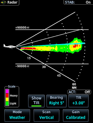
Just before I got to Taylors I did a bit of vertical profiling.  I had that big cell about 60 miles out


Here is the vertical shot.  I was at 7k and my beam was angled up 3 degrees so doing some math, the blue line intersects the storm at around 25k,  The tops are painting around 35k.


Also notice how the ground clutter is pretty symmetrical but the storm is clearly vertical.  Here it is again about 7 miles closer.  Notice that since I am not heading directly at the storm I am now pointing at a different slice of sky and it has a slightly different structure.


After making the turn at Taylors, I went from dark to blue skies.  Home was calling for 1800 overcast so I  had to be sequenced for the ILS 32, circle to 23.  The controller had held me high and then given me a steep descent.  I also had about 20 knots of tailwind up high so when he requested that I drop my groundspeed to 170 and then 150 I replied with unable.  I told him I could as soon as I was level.  
 

He gave me a vector and once I was down top 3000 I slowed to 149.  The approach was fun, I turned final with the airport in view but as I approached the FAF I entered a big puffy cloud so technically it counted towards currency. The approach was easy but the real trick was the landing 20+ knots, of gusty  variable winds with lots of turbulence on final.  Usually I could easily make the 1500 turn off with a headwind but today I just let her roll and coasted off at 2500 feet.  

As I write this the storms are only 30 mile away and we have tornado warnings.  The storms have moved 100 miles in 4 hours.  This was one line I was not going to cross.