Sunday, May 29, 2022

Busy Day Aviating


It started off simply, a quick flight with my dad.  He is getting up there in years, 92 to be exact.  I prepped the plane and CC drove him over so as to minimize ground time.    The plane was out, and after some work and help from the hangar neighbors, we had him loaded and I was running the checklist. We take climbing into the cockpit for granted.  I can see that it will increase in difficulty in the decades to come.

I was about to flip the master on when my mechanic showed up.  This was odd as he had fixed my pressure pumps recently, but I had already made a few flights, and everything was working.  His appearance was soon explained.  A plane had a mishap, and the airport was closed.  

Normally a delay is not an issue and our immediate concern was for the unfortunate pilot, but I couldn’t let dad bake in the heat or we would have a second emergency.  We carefully help him deplane and seated him in the air-conditioned car.  The incident looked really bad at first, the plane looked squashed which is never good.  We soon learned it was not that bad.  The plane had departed the side of the runway and flipped in the soft grass.  The pilot had walked away, shaken but OK.

Later reports from a mechanic that assisted in the recovery indicated that it may have been caused by a locked brake or broken steering linkage.   

I have a portable radio and we listened to ground control.  They were telling planes it may be a while.  I pushed the plane back in the hangar and Dad and CC headed for the house.  Of course a few minutes later they opened the airport.  I called them and they quickly reversed course.  My hangar neighbors were extremely nice and delayed their departure so they could once again help Dad make the climb into the cockpit.  I have to get in first and CC is just not as strong as I, so loading is a bit more awkward.

We had a lovely uneventful flight.  Our route took us by JAX, the old rice plantation and Kings Bay, the submarine base.  Thankfully our landing was smooth, and we tracked the center of the pavement.  We had learned from the first aborted flight and  Dad was able to extricate himself easier by sliding out, and then down the wing before standing.  We headed to the house for lunch and overall was a successful venture even if we made Dad work harder than he expected.  Big thank you to our neighbors that jumped in to help.  Made the boarding much safer.

CC and I were not done aviating though.  I have had a hankering to watch the sun set and test the new settings on my flight displays.  Previously they had been set to a higher value of minimum dimming than I liked.  Bragg Avionics had updated the settings, so it was time to test them.  The blue skies had given way to a high overcast after an afternoon of storms off to our West.

Undeterred, we headed out just before sunset to have a look.  The flipped airplane was parked on the ramp which was how we got the updated pictures.  After surveying the damage and being thankful that it did not happen to us, we headed over to inspect the plane.  Preflight went smoothly, I had prepped the plane earlier so everything was ready, just needed to double check that no one had snuck into the locked hangar and changed anything.

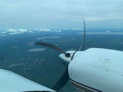
We departed just before sunset and climbed out to watch the sun dip below the horizon.  As usual the colors were stunning, the air was smooth and we cruised down towards Palatka.  The rain was supposed to be gone.  We had major storms 200 mile South but North Florida was supposed to be clear.

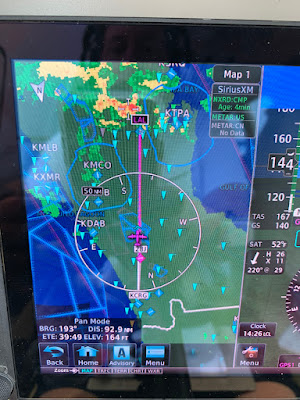
As we turned West passing Palatka heading towards Gainesville, CC noted some lightning off to our left.  The satellite radar only showed a small area of rain to our right though.  I fired up the radar and sure enough, that building cloud was painting bright red.  Out of curiosity I asked the controller what he showed.  He initially said, just light with some moderate rain.  This was what the satellite was saying and based upon that picture, I would have flown that direction.

The radar was painting severe, and we were getting a nice lightning show.  The controller then said his latest update was showing extreme precipitation.  Eventually the satellite caught up with reality.  That little bit of rain to our right, well it too was deceptive.  Very little rain falling to the ground and looked benign on the satellite but it had a core of strong rain and I would have avoided it had it been on our route.

It was soon time to turn North and head home.  We left the light show behind and the last light faded and we were enveloped in darkness.  The new screen adjustments worked though there was some user adjustment to tweak the displays to get them to my liking. 

We finished the flight by cruising over downtown and then set up for a straight in to 14.  I was a few knots fast and decided to stay off the brakes, so we rolled to the 3000’ turn off and cleared the runway.  Was a nice way to end a great day of flying, tower had me monitor ground as we taxied back to the hangar.  The plane was soon secured and ready for our next flight.   

Saturday, May 21, 2022

Back to School

In 1986 Rodney Dangerfield returned to college with hilarious consequences.  Yesterday I headed back to radar school.  Lots of weather South of Orlando but clear up by us.  One area I have struggled with is tilt management past 40 miles. 

I have been studying and was ready to put the lessons to some practical use.  The first important consideration is how far away the horizon is.  As you climb, the distance to the horizon increases.  (Yes the flat earth folks will argue this point.) 

Altitude (ft)        Horizon (NM)    Ground Range

2000                       47.6                        35
4000                       67.3                        50
6000                       82.4                        62
8000                       95.1                        75

With the dish tilted down, the radar gets ground reflection.  So at 2000 feet you would expect to see ground returns out to 47 miles.  You don’t though.  They stop about 75% of the way out.  The reason for this is that as you get farther away, the angle of incidence of the beam gets shallower.  As it gets less than 2 degrees, the energy no longer bounces back.

This means that depending on the distance and your altitude, you may not be able to confirm attenuation for farther off storms.  This all assumes flat ground, a city for example provides flat surfaces to return energy.  Also, since buildings are tall, they can reflect even when they are technically over the horizon.  A 100-foot building effectively increases the distance 10 miles, a 200 footer adds 17 miles. 

How do I know this all works, I went and flew at 2,4,6, and 8k while tilting down to paint the ground.  This worked well and I was easily able to tilt down and paint ground from 5 miles out to the values above.  As you tilt the dish up you lose the ground.  At 8000 for example, 3.5 degrees up paints some ground around 60 miles.  Everything beyond this is weather or something tall on the ground. 

The key to seeing storms father out is to keep most of the beam off the ground but not so high that you scan above the weather.  It’s easy to over tilt.  A 6 degree up has the bottom of the beam 2 degrees above the horizon.  At 100 miles the beam is 18,000 feet above your altitude or 26,000.  This also ignores the fact that the earth has curved away from you about 8000 feet as well so you are really scanning around 34,000 feet.  Easy to miss serious weather that is not a monster storm.  Also at that level the water is likely frozen and does not reflect as well.

After working ground returns, I focused on weather.  I have been trying to get better at that 80 plus mile range.  One tool I am still learning is VP (Vertical Profile).  In this mode you set a bearing and the dish scans up and down.  This eliminates the tilt issue.  You will always see the ground out to the distance previously discussed.  Anything else is a storm or a ground object.  

Above is an example of VP pointing towards clear air from 8000’.  Below is looking at weather, the storm at around 105 miles is clearly visible and matched the XM weather data.


Friday, May 13, 2022

Relaxing

Tuesday was our day to relax. When the light started leaking through the window, rather than rise, I rolled over and caught a few more Zssss. Eventually we started moving and were on the road by 10. We were heading back to twin falls.


We had visited the lower twin falls on a previous trip. It’s an easy hike to a great view. Our visit today was a lot like our last. You drive through a rural residential area and then come upon a dirt parking lot. Last time we got one of the last spaces. Today we were alone.  . 


The hike is only about 7 minutes and today we had the falls to ourselves. We stayed on the observation platform as the plants had taken over. Late spring is way more leafy.


Our next goal was the upper falls trail. To be fair, it is not known for its views but it was a bit harder and we needed a workout. We needed to work off those brownies.  It was a bit hard to find the trail head. I think I would have missed it without Google Maps. Only a few spaces on the shoulder and no marking. We started up the trail and found a small sign with somewhat cryptic directions.


We continued down the trail and found the fence. There was no trail head sign but we went with it. Off we went and the trail headed down. This is never a good sign when you are heading for the upper falls. After a long trek down, we started climbing.


The reviews were right, the view from the top is just the the creek heading for the falls. You could potentially see more but you could also fall to your death so we stayed off the wet slippery rocks.


The way back started easy with a gentle descent. Then we came to the up part and we had to work. By the time we got back to the trail head, I was breathing quicker. Our next stop was for some cold drinks to hydrate and we decided to call it a day as the temperature had risen quite a bit.  It was actually hotter in the upstate than back home.


Our dinner was traditional South Carolina pulled pork BBQ.  Not my favorite but CC really likes it.  We tried Little Pigs Bar-B-Q and they did a really nice job.  Even better were the Chocolate chip cookies they had for dessert in the lounge.


Wednesday when the light peaked in we got going.  Rumor had it that there was a tailwind so I was excited for the flight.  We dropped our car and loaded up the plane.  Pre flight checks were good and we were soon taxiing out.  The airport had some construction and the middle of the taxiway was closed.  This was not an issue inbound as I landed long and turned off past the closure.  


Outbound we would need to go on the runway to circumvent the closed area.  Ground turned us over to tower and tower cleared us onto the runway.  We were told to back taxi as long as we like and tell them when ready.  I mentioned I needed a minute or two more before departure and was told to take my time.  Sort of strange to just hang out on the 11,000 air carrier runway but we did.


The checks were soon completed and with 8000 of runway I called for departure.  The sky was clear and we were soon at 9000 enjoying a darn good tail wind.  Our flight down would only take 1:25.  Our arrival back home was smooth but I had a strong gusty crosswind.  It all worked out well and I planted the upwind wheel smoothly, lowered the other two and gently rolled to the end.


the only trouble we had was that the tug I used to push the plane back broke a weld and we ended up pushing the plane the last few feet by hand.  Luckily my mechanic welded it and I had it on the tug the next day.

Wednesday, May 11, 2022

Quick trip

Between upgrades and maintenance, I have not been flying as much and our travel has been limited. Cecilia had some business in Greenville which made it the perfect trip to work back into travel.

The weather forecast was good. It was supposed to be clear. The winds were another story. They were supposed to be as much as 35 on the nose at 9000 I decided we should fly lower as the gain of 3 knots per 1000 feet would be lost to the winds.

Our departure was pretty clear with just some scattered clouds but just North we had a thin overcast that persisted until mid South Carolina. I had also filed via SAV VOR to avoid the restricted airspace but just after departure we were given direct.

The winds were on the nose but about 5 knots less than forecast. All was good until the controller moved us to 7000 for airspace. This put us closer to the forecast. Our air time was 1:42 which beat the estimate by 2 minutes so all was good.


Our rental car was waiting for us and the Marriott had our room ready so we dropped our stuff and went off to sightsee and get CCs stuff done. CC wanted to reminisce a bit so we drove by her childhood home and also visited the park near where she was living when we met. Finally, we took a stroll downtown.

After a quick lunch we switched to the other side of town. We visited Pelham Mill Park which was the site of the first textile mill in South Carolina. They had harnessed the Enoree river by building a dam and redirecting the water. A long time ago we lived downstream near the confluence of Rocky Creek. We hiked a bit and enjoyed the rapids and then headed to the Marriott to enjoy the lounge snacks and take a rest.

One disturbing story, CC wanted a salad so we stopped by Panera to satisfy her craving. The total was $8.09. I gave the young lady $10.10 and said, keep the penny. She then stared at the register for at least 2 minutes. Finally she handed me a dollar bill and 4 quarters. I asked if they were out of singles and she said no. So I handed the coins back and asked for a bill. She said hold on, she wasn’t very good with money.

I know cash is passé but really? This episode was offset by the excellent chocolate chip brownies they had put out for dessert so in the end all was tasty.


Sunday, May 8, 2022

Surprise Weather

I picked the plane up from New Smyrna on Saturday.  On the drive down I reviewed the weather and it looked cloudier than forecast so I filed IFR.  There was no rain though on our drive and only some broken clouds that looked like they were clearing.  I departed about 40 minutes later and it still looked very nice.

Once airborne, I quickly noticed that weather had formed on my path home.  My first thought was to formulate a plan.  My second was that this would let me get some more radar practice, cool!!!

Checking in with departure, I discussed a plan to avoid it.  The controller took me just offshore.  I have 3 sources of radar, two are sent to the plane and delayed.  I also have the dish in the nose which scans every few seconds. 

The wind was 45 knots from the Northwest.  This meant the storms were moving fast as well.   While the satellite radar is great for the big picture, today it was running way behind.    Using the onboard data and my eyes, I found a nice clear path.  The controller was very accommodating and I was cleared to deviate and then direct destination.

The direct route would have taken me through a pretty big storm but with the right data, I stayed safe and dry.  It was a good reminder to never trust the delayed weather in close.  It had been received only 2 minutes before but was at least 10-15 minutes old.  When I had cleared the weather, it was still showing me about to enter the line.