Wednesday, July 20, 2022

Stormchaser

Elmer Fudd was famous for his quote, "Be vewy vewy quiet I'm hunting wabbits!!", today I could make as much noise as I liked, I was on the hunt for storms, again...   I have some very cool and useful weather avoidance equipment but it is only as good as the operator.  It helped us return safely from OKC and Monday it was really helpful avoiding the approaching storms on my way home.


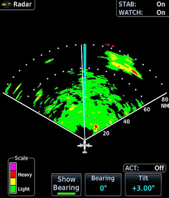
When I awoke this morning there were clear blue skies with storms off in the distance.  Yes they rumbled through later but around 9 AM they were just getting going.  You can see the big picture above (This is XM satellite radar which is delayed but produced by the large NWS doppler network), some near storms, some light rain starting around 50 miles, and some heavy storms out around 80-90 miles.  I headed West and approached the weather.


The close in rain looked impressive during my departure. It is about 40 miles out in the picture.  You can see it has some significant vertical development which makes a difference when using the radar.  Looking at the big picture above, you can see the near rain has 3 distinct parts and we can clearly see them in the image below.  The important controls on the radar are tilt and range.


The radar has a beam that is 8.4 wide and sweeps back and forth.  The beam, like a flashlight is stronger near the center but illuminates that 8.4 degree cone well and there is even some energy further out.  The tilt allows you to adjust where you point the beam and this is critical to accurately imaging the weather.  The above pictures shows the collection of cells clearly.  Given what I am seeing out the window and the returns, I would avoid this. Notice at 3.5 degrees, my central beam is clearly brushing the ground and I am getting a good bit of green ground clutter that is not rain.


Bumping up to plus 4 degrees, cleans up the clutter a good bit.  Notice the far tail looks like it is not as intense (it looked worse on the 3.5 tilt) but this may not be the case.  Since it is further back and I am tilted further up, it may be that my beam is scanning above the more intense rain.  At 35 miles there is not much drop off from the earth curvature, maybe 1000' but my beam is pretty wide out that far out, about 5 miles or 25,000' so I may be missing the important part of the storm.


Tilting up to 5.5 cleans up all the ground clutter but it also makes the rain look less intense than it is.  Lesson here, over tilting to eliminate all of the ground clutter is a bad idea. You are sending your beam into the top of the storm which is likely above the freezing level and will give you a false impression of the storm intensity.  When you are higher up this is less of a problem but you want to accept a bit of clutter to get the best weather image. 

Looking out further, there were big storms at 80+ miles (see the first picture).  The easiest way to see that far is to drop your beam near the horizon.  The horizon is about 60 miles so at 80 there is not much drop off to hide weather.  You do need to keep your beam flat at that distance or you will send your energy over the storms.  You can see at plus 1 tilt the ground is covering the first 60 miles but we can clearly see the storms at 80 miles and the radar is warning with those red bars that there is more bad stuff off screen.  If you want to see in the 0-60 range, you will need to re-adjust the tilt for that range.


We can pick the bean up a bit to reduce the the ground and plus 3 seems to be a good compromise at this altitude.  We still have a good bit of clutter and we can see the near rain reminding us we will need to turn soon to avoid it. 


Tilting further we see that plus 4 is likely the limit of good. We can see the storms but we are making them look benign when in fact they are anything but.


Plus 5 looks cleaner still but is a mistake as you are losing too much information. Notice in the image below now that we have moved West and a bit closer to the tail of the near rain (it is only 20 miles), plus 5 is capturing the heavy precipitation and giving us a clean picture. Here is the plus 5 below, zoomed in.  When working less than 20 miles  or less, you can be more aggressive with the tilt.  This is also useful when making an approach over a city where you will get significant clutter which can be hard to differentiate from weather.


The far strong storms and the near storms imaged well but what about stuff in the middle?  There was a mass of light rain in the 40-60 mile range.  This did not look like much from the cockpit.  What did it look like on the radar?


Frankly it is hard to distinguish from the ground at plus 3 though the near and far rain in clear.  Tilting up to 4.25 cleans up the clutter but doesn't paint much.  We do have the throng storms at 70 miles that let us know we are tilted correctly to see anything big.  The reality is we need to get closer to get a better image.  At cruise speed I am still 12-13 minutes away with plenty of time to make a course correction depending on what happens as it moves inside 30 miles.


The clouds were starting to build so I made a strategic retreat.  This gave me an opportunity to use the radar to image the coast.  Pointing down we clearly see the coast.  The only odd return is the island that has grown off the mouth of the St. John's river.


We can bring the beam up a bit and look wider.  This is a better setting but still too low to be very useful for weather.  The coastline with all it's development reflects a lot of energy back.  The Red on the left is downtown Jacksonville and the yellow on the right is St. Augustine.


Our island is still there or is it?  Not really, there is no new land off the coast of Florida.  Just like buildings, large ships at sea are great radar targets.  The energy easily bounces off the side of a metal ship.   Below is a clearer picture.  There are actually 3 ships at anchor, each visible on radar.


On the left you can see the coast and just right of center is likely someone else's radar.  When another plane is is heading towards you and sweeps across your radar it makes a radial spike.  The radars are smart and use a variety of frequencies, the unit will adjust to ignore the other radar and they seldom show up for more than 1 or 2 sweeps.  Talking ships, below is a shot from Monday by Savannah.  The left is the coast, the right is more than 25 ships at anchor off Savannah.


I was ready to head in but the clouds had thickened a bit and were lower.  Approach was nice enough to provide a pop up IFR which avoided a detour around the clouds.  I joined the GPS 32, circle to land 23 as 32 was being inspected by FDOT.

Bases were 1,200' on the approach but much higher over the field.   It was a fun approach and I soon had the plane away well before the storms arrived.

Friday, July 15, 2022

A Gulf Low

Getting home always seems harder than getting there.  It could be that on the way out we have left a day early to pick better weather or used other strategies to make the conditions more favorable.  It could be that we always arrive home in the afternoon which is prime thunderstorm time.  It could be rotten luck, like the 30 knot headwind outbound and the 3 knot headwind heading home.


Regardless, getting home this trip presented a challenge.  I had been watching the weather but once out there is not much you can do to change things except wait it out.  So as I watched the low pressure move over the gulf, South of Louisiana, I knew that the afternoon might be a challenge.  Departing OKC was hot but clear.  I had another complicated clearance that included a VOR, radial and distance plus more.  Of course once airborne it was direct KLUBB intersection direct which was basically direct.

We headed back to HAB because the fuel was still the lowest price I had seen in a while and it had everything we needed.  2:45 later we were at the fuel pump after seeing mostly clear skies.  Technology is great and we had watched the mess over Louisiana, Florida, Alabama and Georgie get messier.  I was not really sure there was a way through but I figured we would fly up to the weather and at least get closer to home.

We launched into the blue skies and started watching and planning.  There were two lines, One ran from the gulf to the Atlanta area, the second ran from the gulf and curved around towards Amelia Island.  The first was looking good with a break at Auburn, AL.  The second looked like it may have a gap opening around Jesup, GA.  I had been watching the storm for 3 hours and it was racing North so the idea of trying to stay North of it and then South through a gap was not too appealing.

As we got closer I saw the rain in the panhandle was diminishing and I could get behind the weather.  This looked better and there were plenty of airports along the way I could use to divert if things did not go to plan.  The controllers were super helpful and clear me KAUO MAI  (Auburn and Greenville VOR).  

We were still in bright sunshine as we approached Auburn.  I had the onboard radar going on my MFD and the Satellite radar on the main GPS.  Auburn was a wall of clouds and with some deviations we made a nice turn and headed South.  The radar was showing just light rain it was not enough to really hear it but you could see it on the de-ice boots.

We continued South and broke out between gray layers.  It was sort of odd to go from a sunny day to dreary day in seconds.  We had about 100 miles to go before we were South of the rain.  Satellite was showing yellow all the way but the radar was showing mostly clear or green with a 5 mile band of yellow.

We went back into the soup and had pretty steady light rain with the 5 mile band of yellow still looming ahead.  I started picking up a few scattered pixels of red on the radar off to the right so we deviated a bit left and had about a minute of steady rain and then we were back out.  We were on the back side and from there we were able to stay dry and mostly VMC.  There were still some big cells but they were easily avoided.  

Approaching MAI I asked for direct Valdosta and after confirming the surrounding airspace was cold, was sent on my way.  The last big storm was over Valdosta and once we cleared it to the North we popped out again into sunny skies as if it had never happened.   We could see storms off in the distance and some pretty rainbows but the hard work was over for us.

I should say sunny skies except over JAX.  As we passed over downtown in bright sunshine, JAX had it's own personal rainstorm.  CC said it was like the cartoons where a character has a personal rain cloud.  It was a nice sight and I was glad it wasn't our problem.  We made a satisfactory arrival with gusty winds and soon had the plane away.

It was a flight of contrasts.  Busy and complicated departure from OKC followed by straight cruising.  Then we the best and worst weather.  I would not have attempted this in the Bonanza, the delayed radar is just not good enough when in close.  That said, the active radar is great within 60 miles and while you can  see weather farther, having the satellite for the big picture is also invaluable.  The combination let us traverse an area of severe weather weather with a mostly smooth ride and no more than light turbulence and light rain.  


Our route as flown.  The rain shown is not what we flew through.  It looks like it captured the rain picture around the time we turned South.  We did not fly through that cell by Valdosta, by the time we arrived it was smaller and well North.

Thursday, July 14, 2022

I'm from the government, I'm here to help you

The home of the FAA is in Oklahoma City, Oklahoma.  Technically headquarters is in DC but most people think of OKC when they think of the FAA.  From what I can tell it is there because of Senator Mike Monroney, surprise politics and money, who would have guessed?   To be fair, in this case the government was here to help me.  I attended a twelve hour class that covered survival, spatial disorientation and hypoxia.  The class is meant for a broad audience so some of what we learned was not directly specific to my type of flying but it was all good.


Survival started in the classroom where we discussed what if?  What would you do?  We all had about the same ideas.  Evacuate, First Aid, Shelter, Signal, Water, Food.  The order can be tweaked based on the circumstances but its all pretty basic.  They emphasized the STOP method!  That means Stop, Think, Organize, Plan.  It is a reminder that running around is not necessarily useful, be deliberate.


We covered a broad range of topics in the classroom and took breaks for practical lessons.  One was the airline evacuation scenario.  We did 3 evacuations, one through the front door, one through an over wing exit and the final was again through the door with a smoke filled cabin.  When your visibility is only 1-2 feet it changes the process.

Our next adventure was in a big freezer where we tried various shelters.  They keep the freezer at a comfortable 10 degrees F.  We sat in a repurposed life raft and found it was a much better insulator than our crashed airframe.  Yes they had a real airplane cabin we got to huddle in to really get a feel for the cold.  We also tried those space blankets and they were surprisingly effective.

In the afternoon we went outside to start some fires.  This is likely the only time I will start a fire on a government facility without being arrested.  We tried various fire starters and learned the practical side of making things burn.  Starting a fire in the wilderness is harder than it looks.  I have practiced this skill as part of other classes and it is an art.  The key is to have at least something to cheat a bit.  I have a fire starter and dry kindling in my flight bag.  Do you?


We then headed for the pool to spend 3 hours working on water survival.  We got to work with rafts, learned how to work together in the water, how to manage injured survivors and even rode the basket.  They have a rescue basket on a hoist hooked to the ceiling.  We each got a turn to swim out and climb in to do a simulated lift to 15 feet or so.  The instructor gives you a spin as you are lifted to simulate the ride on a real hoist.  I asked for the double E ticket ride and it was a blast.  After our swim we got to go home for the night and rest.


Day two started with spatial disorientation.  The instruction was both classroom and practical.  They placed one of our group in a Baranay chair (Basically a fancy office swivel chair) and demonstrated how easy it is to confuse a blindfolded person which direction they are spinning.  We then took turns in a simulator where we flew instruments while they rotated the box.  This allowed them to induce the confusion between what the instruments say and what your body tells you.


Having survived my Sim flight we moved on to Hypoxia.  We learned the classroom stuff and then prepared to walk around at 27,000 feet.  Not really, we would stay firmly on the ground.  They have a chamber where they can change the percentage of Oxygen in the air.  Normally this is 80% but if you drop it to 6% it's the same as being at 27,000 feet.  At this altitude most people have about 5 minutes of consciousness.

Not all of it is useful though as you get stupider as your brain is starved of O2.  We were given a clip board and a pulse oximeter and sent in.  The instructors wore Oxygen masks so they could watch us and keep us safe.  Stepping in I quickly had a slightly dizzy sensation followed by tingling at the extremities.  This is the  purpose of the simulation, you want to learn your symptoms.  We were told to experience no more than 3 symptoms and then go on Oxygen but in no case to let our level drop below 60%.  Typically when we fly we want our level to stay at 90% or better.


By 70% I had my symptoms recorded and donned my mask.  A few breaths and I was back again and my pulse ox was up to 100%.  Different people react differently but your symptoms stay the same over timer.  The key is to know how you react so that at the first sign of hypoxia you can take action.  We did it in two groups and while it was fun to do, watching the other people was also quite amusing.  After this it was back to the airport and time to head home but that's another story.


Oh, we visited the FAA store after class and I bought a cool FAA T-shirt.  I'm sure that will get some looks on the ramp.


Wednesday, July 13, 2022

Oklahoma City

I needed to be in Oklahoma City by early evening so we we were in no rush to leave Arkansas. We slept in and then headed to Atalanta Lake. No that’s not a typo, that’s what its called. The lake is a man made reservoir created in the 1930s. It has been upgraded with a really nice walking path. Even though it was a scorcher today, the morning temps were low 80s and had there was a great breeze.

We did the round the lake walk clocking in at 2 miles.  After cleaning up and getting some food, we were off to OKC.  It was a quick one hour flight.  I fired up and requested my clearance.  I was caught off guard as my clearance was the Highfill Eight departure then as filed.  


This is not a busy place and when I pulled up the procedure, it was simply turn to 180 and climb to 5000.  I already had been cleared to 5000 and told to expect 8000 within 10 minutes.  After fully briefing the departure and completing the pre departure checks, I called for take off.


Tower cleared to take off with a clearance to turn on course, no departure procedure.  This seems to be a theme in most places with piston aircraft, give out a procedure and then don’t use it.  I can’t complain too much, we were cleared right up to 8000 and enjoyed 10-12 knots on the tail.


OKC is a pretty big airport and there are two choices for parking on opposite side of the airport. It's only big because of the FAA and the military.   Approach was on top of things, checking in we asked where I wanted to park and the told me to expect 35 Left.  It all worked well except that there was a string of traffic for 35 Right.  This created a slight detour but we soon were pulling up to the FBO.


They had our car ready and we dropped our stuff off on the way to check out Route 66.  Oklahoma is not a new state for us but we have never stayed overnight.  We drove out of town to the iconic route.  We stopped by the Arcadia Barn, a Route 66 landmark.  It is a restored 1898 barn, they built them round thinking it would keep it safe from twisters.  Unlikely but then again it’s still standing.


After the Barn we headed downtown to see the Bricktown.  This is the entertainment district.  Basically they dug a 16 foot deep trench and then a four foot deep canal.  This winds past the local minor league stadium and is surrounded by bars and restaurants. They also run boat tours down the canal.  We took the walk but skipped the boat tour.  After our walk we drove to a cool monument that was further down the ditch. It was sort of odd to see a canal in the middle of the city but if you squint really hard, maybe it makes sense.

I had an 8PM meeting to start my class so we headed back to grab some food.  We had notice that OKC was heavy on Mexican food.  Reading the reviews we saw some good choices around us and after some serious study we chose Taqueria Sanchez.  


It was a nearby food truck with a high rating and 917 reviews.  We ordered tacos, a burrito plate and a side of avocado.  The food smelled great and tasted better.  It came with a side of spicy pickled veggies a bonus. I had to be out of the hotel at 7:15 the next morning so we called it a day rather than going out clubbing.


Tuesday, July 12, 2022

Off to Walmart (#22 Arkansas)


I had another class to attend. This time it was in Oklahoma City. Not my favorite place to go in the summer, especially with forecast highs around 102. I had to be in OKC on Monday at 7:15 and given all that can go wrong, I decided  leave Saturday and go most of the way so I could drive the last bit if needed.  I also was also looking to add another state and Arkansas was along the way. Not just Arkansas, but Bentonville, the home of Walmart. Ok to be fair, the Crystal Bridges Museum of American art had caught my eye.

I had been watching the weather and my expectation was for no issues on departure or on arrival in Arkansas. I was concerned a bit about storms along the way, especially by Memphis where we planned to stop for gas.  When I woke, Memphis was getting hit pretty hard and rain was approaching our fuel stop. I had backup ones but I had chosen this stop because it had a great price on gas. Departing the weather was good at home but the rain was about 10 miles North of our stop.


We pressed on and after reaching 10,000 we had a new issue. There was a line of storms forming that started at Montgomery that extended into Georgia. A quick request to ATC and we were cleared MGM KHAB. Problem solved.  Our next problem was headwinds, 30 knots on the nose most of the flight. There was no solution for this other than extra gas. Passing Montgomery we made the turn and it was smooth sailing. While we were busy rounding the storms, the rain at our stop moved on and started to dissipate.

We landed and pulled up to the pump. The plane ahead was still loading and it was like watching a clown car in reverse. Six people squeezing into a Cherokee 6. They were trying to get going but they couldn’t quite figure out the sequence to load. They finally got in and the pilot got the engine spinning after 3 or 4 attempts.  We topped off as the gas was the cheapest I had seen in quite some time. I had a bit of trouble as the hose lock was broken but the manage came by and helped me. I like country airports because they are easy in and out. Departing, Memphis had our clearance and we were soon on our way. I thought I might be rerouted as my track took me right through Memphis class B airspace.

I should not have worried. It was empty, I even called approach once to make sure they were still there. The headwinds were still with us but we soon landed in Arkansas. I had to land long as there were 4 Black Hawk choppers blocking the taxiway I needed. We taxied around and soon had our stuff in the rental car.


After swinging by our hotel to check in and drop our stuff, we headed to the museum. It’s a new museum and it’s pretty stunning. We wandered a bit and took a tour of a Frank Lloyd Wright house they had moved to the site. We strolled through outdoor sculptures and topped it off by seeing a copy of the constitution printed in 1789.

The museum is pretty cool but it is the worst marked facility I have visited. They have great trails but no maps. There are a few diagrams in the museum but they are few and far between. Eventually we figured the place out.  I would recommend it if you are in town, it was very cool to see both new and old American art.


After the museum we headed downtown to see the home of Walmart. We took a quick spin through the Walmart museum. It was more of an add than a museum but it was free. Downtown is quaint but after some walking we headed back to the hotel. We found some tasty BBQ and enjoyed some pork, brisket and ribs. After that it was time to get some rest.