Monday, October 30, 2023

Fogged Out

Monday morning the Southeast decided to have a blanket of fog far and wide.  Typically you get fogged in, this day we were fogged out.  Our Leaf peeping in the Carolinas was over, we had to turn in the rental car and head home.  While this delayed us a bit, Sunday morning we had awoken to a clear warm day.  We headed up towards Highlands NC, which I feared was a bit high for peak leaves at around 4000'  Our best leaves had been around 2000'. 

Our first stop was Whitewater falls, the falls are 411 feet and the highest falls East of the Rockies.  It’s an easy .4 mile walk to see the falls and you can get a better view by walking down 153 steps to the observation platform. It scores a high rating.  I rate falls based on the view divided by the effort to see the falls.  Great view and low effort equals a high rating.   There is also a great view of Lake Jocasee along with the surrounding mountains and foliage.

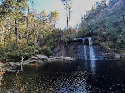
The next stop was near Cashiers, Silver Run Falls.  The falls are only .2 mile walk from the road along a flat path.  They are a small but nice water fall into a pond.  You can walk across some flat rocks to get a better view and I don’t usually advocate climbing across dangerous rapids but this particular ford is only a few inches deep and the flow is slow.  We were also wearing our waterproof hiking boots.  The boots needed a wash by now as the previous days had been quite dusty.

Our next two falls were repeats but we were so close, we figured we should revisit.  Dry Falls and Bridal Veil falls both offer the opportunity to see the back of water. There has not been much rain lately so Dry falls was less than half the flow of our last visit. 

Bridal Falls was more like Bridal drip….  We enjoyed both and finished by heading to downtown Highlands.  I had planned one more hike, it was a 4 mile hike with some big elevation changes to see Rainbow Falls and 2 others.  I gave CC the choice of  hike or town and thankfully she chose town.  With so little water I figured it was not worth the effort this trip.  Also it had warmed up to near 80 so maybe next spring.

As towns go, Highlands is a bunch of overpriced stores.  But it has a quaint look so I guess you're paying for the quaintness.  My guess is that they cater to the second home crowd that wants to spend $40 for a small pizza.  It is a nice stroll though, we did make one important purchase, Ice cream.  So to summarize, we chose ice cream over a strenuous 4 mile hike.  Luckily a recent upgrade reduced the planes weight several pounds so I guess I will add it back personally.

We took a slightly longer route back to Greenville but it kept us in the foliage zone and we really enjoyed our last taste of color.  We made a few stops at scenic overlooks to stretch the magic but eventually we made it back to the hotel for some snacks.  We did head downtown in the evening for a stroll and met up with some old friends for dinner.  

Going to sleep, the forecast was for Low IFR and it was supposed to persist until almost noon.  I backed up my alarm clock and went to sleep secure in the fact that the sun would eventually burn it off.  The wind forecast was for just a light headwind so overall looked like a nice ride home.  The morning weather did not disappoint.  I rolled over and looked at my phone around sunrise to see the fog had formed as promised.  I put the phone down and went back to sleep till 8:30.  

The hard part with fog is that it’s there and then it’s gone.  The 8 AM report had the temperature and dew point the same, I knew we just needed a few degree spread to clean it all up.  What I didn't know is how quickly that would happen.  Also the forecasts on these events are usually terribly off.  Since it would take a bit over 2 hours once we headed for the airport to get ready and get home I needed o guess when to leave so that we arrived with safe approach options.

I figured 9:30 would be a good time to go.  Our departure weather was perfect and  the weather just South of home was good so worst case we could fly another 10 minutes, gas up and wait it out.  I like Greenville because it's such an easy airport, even if it is a bit overpriced.  It's just 12 minutes to the FBO, they handle the rental car return and we preflight and load the plane.  They did offer to carry our stuff, it is full service and they are very nice but we just had stuff for 3 days so we handled it.

Departure is also easy with 11,000 of runway, we had plenty of margin.  We were number one for departure, had a mostly unrestricted climb to 9,000 and were on course to Savannah VOR expeditiously.  That was the good news.   I knew the winds were going to be strong around Greenville but the models said it would drop off around Augusta and then be negligible from Savannah home.  The models were really wrong.  First, they underestimated the wind by about 10-15 knots and the strong winds were present deep into Coastal Georgia.

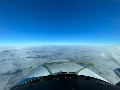
Right before starting the engines I checked the weather one more time and our home airport had gone marginal VFR.  We still had a lot of low clouds on the rout though.  Around Saluda, SC we found the low clouds, they looked like they were trying to break up.  I guess that's how you get broken clouds.  The cloud formation was interesting. the clouds formed in long lines, like they had been farmed.  

I doubt anyone had a tractor that high up and if I had listened more during meteorology class I may have better understood the phenomenon.  As it was we just enjoyed watching them and snapping pictures.

The field was still marginal on our arrival and I was set up for the GPS 32 approach.  We were descending just off the coast in clear air with clouds over land.  As I descended for vectors to final I saw the airport off to my right and asked for the visual.  The controller seemed very happy to give me the approach as he was able to just send me to tower and did not have to vector me.  

We continued our descent and slid under the clouds to join a 3 mile final and the glideslope.  We had an easy touchdown a few minutes later.  Other than the headwinds which added 12 minutes and hitting a humongous bug at about 800' that left a big goo patch on CCs side, it was a nice uneventful flight.  The plane was soon pushed back and CC cleaned the bugs off the wings while I took the goo off the windshield.

My days are numbered


Like sands through the hourglass so are the days of our lives.  More importantly, the airplane is running out of days until annual.  I have flown more hours in October than any other month this year.  With around 30 days left, it was time for one more trip.

CC and I liked the leaves in New Hampshire so we decided to check out their Carolina counterparts.  The flight up was uneventful which is a word I like when describing my travels.  We were cleared SAV direct GSP. Passing Brunswick, we got direct destination. We even had 3-6 knots tailwind..

The South East had an overcast at around 5000 and outbound we slid through the clouds which were just a few hundred feet thick.  The clouds stayed with us most of the flight but we did have patches of clear.  The arrival was easy with a visual approach to runway 22.

There is only one choice for FBOs at GSP and they charge a bit more than other like operations but they have great snacks.  We bought 20 gallons of overpriced gas but scored some snacks, drinks and ice cream.  I had a Drumstick, CC went for Haagen Dazs.  The Marriot had our room ready early so we dumped our stuff and headed off to leaf peep.

I had planned a mix of old and new.  Our first stop was Ashemore Heritage Preserve, which was new to us.  We took a 1.5 mile hike around Lake Watacoo. I wrote Lake with a capital “L” but it is really more like lake with a small “l”.  I looked to see what the difference is between a lake and a pond and there is no internationally recognized standard.  So I guess they can call it a Lake.

The trail was advertised as gravel but it started as rocky and then became dirt.  The dirt was easier on the feet.  Overall the hike was easy.  It was near 80 so a bit hot but generally nice.  The colors on the trail and around the lake were quite nice.

Our next stop was just down the road, Wildcat Wayside. We had been before, it’s a 3 in one stop with three waterfalls and only 1.1 miles of hiking.  There are 2 trails to the falls and we went out the hard one and in on the easy.  The first two falls are just a short distance from the road.  The last fall is the long walk.

After powering our way to the main falls we found out they were turned off for maintenance. Ok, maybe it’s just the end of the season and the water has run out.  No water was a bummer but it was still a pretty walk with lots of color.


Our final stop was Bald Rock which was also a repeat and just a few miles up the road.  As we ascended the mountains, the colors were getting better and Bald Rock did not disappoint.  We sat out on the rock looking down to the valley.  Colors looked near peak.

It was time to eat and I had read about a place along the way.  We stopped at Burly Bills BBQ.  The place is only open 3 days a week and Friday is one of them.  It is basically a food truck but they have a luxury seating area, benches and a tent.

There is also a junk store adjacent.  After ordering we wandered by the store and it was junkier in person than from a distance.  Our food was soon ready which was good as I saw nothing that I wanted.  CC had the pulled pork Sandwich.  I had the brisket and rib platter.  I was going to give the place an 8 but they apply the sauce and they were a bit skimpy so they get a 7.5. 

It was a great day to sit outside and have BBQ, the breeze made it quite comfortable and kept away any flies.  CC also had the sweet tea and that gets a 10, sweet but no overly so.  After filling up on BBQ we drove back to take a rest. 


We slept in on Saturday before heading off to peep more leaves.  Lots of good foliage to see but very inconsistent. Greenville is still early in most places and higher elevations appeared past peak so we decided to head up North of Rutherfordton. It’s an area we have visited before but we went to some new stops.

The color was great but came and went seemingly randomly. You look one direction and it’s brilliant and the other brown.  Our first stop was Tom’s Creek falls.  When we showed up parking was at a premium, in addition to hikers the hunters were out with their dogs.  We were a bit confused as to what they were hunting but didn’t give it much thought.  The hike is pretty easy, about a half mile and the falls were quite nice.  Again the lack of rain made it a low flow event but there was enough.

Our next stop was West towards Asheville. The kitsuma peak trail was billed as an easy 2 mile hike to a nice overlook.  The trail started as a gentle rise along I-40 and then had a series of switchbacks to ascend the peak. The slope became much steeper yet  we persevered and reached the peak.  The view from the summit was marginal due to the many trees.  Overall great exercise, some good color on the trail but a lot of effort for marginal views.  There was an additional overlook just down from the summit which was nice but unless you want the workout, don’t bother.


Walking down, I encountered a lone hunter.  They are very high tech with the dogs wearing GPS collars and an iPhone App to track the hunt.  I asked what they were hunting, it was Black Bear.  I am not sure what worried me more, a bunch of guys with guns trying to kill something on the hunting trail or the fact that there was a bear ion the adjacent property.  I had read that bears were roaming the Ashville streets not long ago.  Our next stop had less hunters but the smell was sure to attract bears...

We headed off for our next repeat visit.  Keeping with the BBQ  theme, we went back to Smokey and The Pig.  It’s always a danger going back because the food might not be as good as you remembered.  I can say, the brisket sandwich was still excellent.  Not a fancy place and we sat watching the highway while eating.  

Our last stop was Furman University. We used to rollerblade out there in the day and it’s a really pretty campus.  We arrived and drove to Swan Lake which had no swans but did have geese.  Some of the geese were fighting but overall it was peaceful with some nice colors.  In the South you really have to plan around football.  As we looked at the lake I checked the schedule and it was Furman’s Homecoming. At most universities this would have made the campus a madhouse.

Furman has only 2970 students so it is much lower key.  We drove down the center of campus and right by the stadium. The game was in full swing yet we had no issue driving around.  We were ready for a break so we headed back to the hotel to chill.


Thursday, October 12, 2023

Icing and the Big Apple (#13 Maine, #12 Massachusetts, #11 Rhode Island, #10 Connecticut)

Monday had pretty perfect weather and we decided to fly home.  The Lows were now North of us so while we had mostly clear skies, we had a strong flow heading up from Florida which meant headwinds.  We had a lot planned for our return home today and ended up packing in a bit extra. 

We departed Laconia, NH on time, we had one last look at the lake, now with the colder air covered in a light mist.  The departure was clear but some of the mountains had clouds clinging to the sides.  A good reminder to plan departures carefully. Our first stop was Sanford Sea Coast Regional in Maine. We had done the sightseeing the day before, now it was time to claim the landing.  It was an easy in and out and we soon were heading South towards Boston.  

I usually go IFR on these long cross countries but today we would be making several stops and with the good weather, I used flight following instead.  Heading towards Boston, I was not sure if they would let us through the class B airspace.  I could climb to 8500 but that would make descending for New Bedford, really steep.  Luckily it was a slow day and I heard the magic word, “cleared into the Bravo airspace”.

This let us cruise a bit lower and have a great view of Boston.  It also facilitated our descent into New Bedford Mass.  This clicked another state off the list.  We landed, taxied back and were in the air in just a few minutes.  I have been to Mass many times and we decided to forgo any direct sightseeing this trip.

The next stop was just 21 miles away in Rhode Island.  I had studied the state quite a bit and could never find anything to visit so this again was a technical stop.  After landing at Quonset State Airport, we soon launched for Danbury Connecticut.    This leg was a quick 94 miles.  Danbury was really just a fuel stop as CC and I have both toured Connecticut before.

I do a good bit of planning for these trips and especially the airports.  One thing I missed was the arrival into Danburry.  The approach to runway 26 is over a steep hill with trees.  They have a tall tower with a flashing red light to remind you not to hit the trees.  The Baron has the ability to descend rapidly so this did not create a real challenge but I was not expecting it.  We did a quick turn, added some gas and hit the facilities.  Our next leg would be rather busy.  From the ground, pictures do not make the hill does not look that imposing, it is and much more so from the air.


Departing Danburry we headed for the Hudson river.  There is a VFR corridor that allows you to fly down the river and sightsee New York.  You need to take a class online before doing this so you know the procedures.  Basically you fly between 1000 and 1300 on the West Bank (going South).  You have to stay below 140 Knots.  I chose 130-135 to provide positive control and to stay within the parameters.  

As you fly the river, you really need to pay attention, lots of traffic.  There are 6 mandatory reporting points and the trick is to be precise and quick.  This way you can hear where everyone is and what's going on.  In my case I say “Baron [Reporting point Name] 1100 Southbound”.  CC did most of the pictures though I clicked blindly with my phone a few times as I was focused on the flying.

The second to last point is the Statue of Liberty.  We had a great view and CC snapped all these pictures.  South of the Verrazano Bridge you are back to regular rules but still under the New York Airspace.  I had filed an IFR plan that started at an intersection called DIXIE, which is just North of Lakehurst NJ.  

Many people believe IFR plans must originate at an airport but they don’t.  You can use any fix in the system and I did.  I called the local controllers which you can find by looking up the nearest airports and seeing the frequency.  McGuire Approach had my clearance and I was soon cleared down to North Carolina.  


I had filed V1 which runs down the coast from DIXIE  to Norfolk and then direct Rocky Mount Airport.  It does seem odd that DIXIE is located in New Jersey but we went with it. Right after getting our clearance the skies went from clear to partly cloudy.  We initially were at 6000 but I had gone up to 8000 for better economy.  We had been fighting 15-20 knot headwinds since Maine so was trying to optimize as much as possible.

We were in and out of the puffy clouds and though the thermometer said 32 degrees, they were just wet.  As we progressed further the puffy clouds became a layer and then the temperature dropped to 31 degrees.  I was alert for Ice and had the pitot heat on.  I started to see traces on the windshield and immediately turned on window heat and the prop heaters.

At first there was nothing on the wings but as I watched, I started to see rime ice accumulating very slowly.  Even though the plane is made for flight into known icing conditions, I was not sticking around.  I told the controller we had ice and needed 6000.  We got it quickly and headed down.  As we got to 7000 we broke out and at 6000 the temperature was just above freezing.

I had resisted cycling the boots because the book says you need to wait till you have ½ to 1 inch of ice before cycling.  This keeps you from prematurely breaking the ice and leaving gaps.  I had maybe a quarter inch but since it was starting to sublimate on its own and the temperatures below were much warmer, I cycled them.  I have exercised them at least monthly since owning the plane.  This was the first time I saw them shed ice.

It just popped off, it was very cool.  It got about 90%, I would have waited longer if I was still in icing but I wanted to see them in action before it all sublimated.  The rest of the ice slowly disappeared.  There was a bit around the inlet scoops that took longer to go than the rest but it was soon all gone.  My first icing encounter had a good outcome.  I never would have ventured there in the Bonanza.  In the Baron I was ready for it and had an escape plan.  When I reported it, the controller had all sorts of questions and I have to say I delayed answering him a bit as I prioritized getting out of the ice and then playing 20 questions.


The ice was not supposed to be there.  The clouds were not supposed to be there.  We picked up the ice as we flew South over the Delaware bay. My guess is that the warm air below and the water combined to make these clouds just a bit different.  It is a good lesson to always be on the lookout.  There were no other reports and the controller seemed to be as surprised as I was was.  Also as we started down the ice accumulation seemed like it was dropping off.  It may have been a very local phenomenon.  That said I was not sticking around to test it.  

The rest of the trip to our fuel stop was uneventful.  We dropped by Rocky Mount again because they are convenient and had a great price on gas.  After that it was just a bit over 2 hours home fighting those headwinds again.  In the end the headwinds cost me about 20 gallons of gas and almost an hour but it was a great trip and another learning experience.  We flew around 2200 miles over 13 flight hours for an average ground speed of 168 knots.  Not too bad given the constant wind in our face.