
In 1986 Rodney Dangerfield returned to college with hilarious consequences. Yesterday I headed back to radar school. Lots of weather South of Orlando but clear up by us. One area I have struggled with is tilt management past 40 miles.

I have been studying and was ready to put the lessons to some practical use. The first important consideration is how far away the horizon is. As you climb, the distance to the horizon increases. (Yes the flat earth folks will argue this point.)

Altitude (ft) Horizon
(NM) Ground Range
4000 67.3 50
6000 82.4 62
8000 95.1 75
With the dish tilted down, the radar gets ground reflection. So at 2000 feet you would expect to see ground returns out to 47 miles. You don’t though. They stop about 75% of the way out. The reason for this is that as you get farther away, the angle of incidence of the beam gets shallower. As it gets less than 2 degrees, the energy no longer bounces back.
This means that depending on the distance and your altitude, you may not be able to confirm attenuation for farther off storms. This all assumes flat ground, a city for example provides flat surfaces to return energy. Also, since buildings are tall, they can reflect even when they are technically over the horizon. A 100-foot building effectively increases the distance 10 miles, a 200 footer adds 17 miles.

How do I know this all works, I went and flew at 2,4,6, and 8k while tilting down to paint the ground. This worked well and I was easily able to tilt down and paint ground from 5 miles out to the values above. As you tilt the dish up you lose the ground. At 8000 for example, 3.5 degrees up paints some ground around 60 miles. Everything beyond this is weather or something tall on the ground.
The key to seeing storms father out is to keep most of the beam off the ground but not so high that you scan above the weather. It’s easy to over tilt. A 6 degree up has the bottom of the beam 2 degrees above the horizon. At 100 miles the beam is 18,000 feet above your altitude or 26,000. This also ignores the fact that the earth has curved away from you about 8000 feet as well so you are really scanning around 34,000 feet. Easy to miss serious weather that is not a monster storm. Also at that level the water is likely frozen and does not reflect as well.

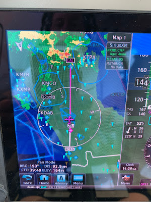
After working ground returns, I focused on weather. I have been trying to get better at that 80 plus mile range. One tool I am still learning is VP (Vertical Profile). In this mode you set a bearing and the dish scans up and down. This eliminates the tilt issue. You will always see the ground out to the distance previously discussed. Anything else is a storm or a ground object.

Above is an example of VP pointing towards clear air from 8000’. Below is looking at weather, the storm at around 105 miles is clearly visible and matched the XM weather data.

No comments:
Post a Comment