Tuesday, July 27, 2021

Mostly Nothing With Something Special


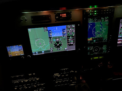
When you cross into Kansas you know it. It’s flat and there’s not much there. The synthetic vision in the plane is often useful in navigating but in Kansas it was just brown.


When we got to Wyoming CC remarked that it had a lot of nothingness. The nothingness has more character with rolling hills and vegetation but almost no trees. While this is true of the South East portion of the state, it does have some interesting and beautiful features.


Saturday we headed off to Mountain Bow National Forest. The Forest is about an hour West of Laramie. We were on the hunt for some stunning views but first we had to find our way.  As we headed out Google maps suggested an alternate route and 3 miles in the paved road ended. Not wanting to do 7 miles on gravel, we backtracked a bit. 


This would not be our last encounter with dirt roads. Wyoming has many.  We got smarter though and mostly stayed on pavement until we were in the park.  Entering the area we stopped to pay the use fee and hit two snags.  We did not have $5 and we had no pen. The first problem we solved with a $10 bill, you can pay for 2 days on the same pass.  As we pondered our next problem a truck pulled up with two rangers.  I asked if they had a pen and they let us use one, who said your government is not useful.  

With the problems solved we drove on to Lewis lake.  The road was again gravel and we got the rental nice and dusty, not as bad as the badlands but it was pretty bad.  The park was pretty busy but we scored a good space along the road.  It required some tight parallel parking which CC was skeptical of but the car was soon in the space.  Something about the steep drop off made her nervous, go figure.


We headed off on a 2 mile hike, sounds easy but it had a good vertical component and we were starting around from about 9000 feet.  The path was pretty good and we worked our way up the mountain.  The further we went the more vertical it became.  The trail does go to the top but that part is rated as hard.  We stopped when we could get a view of the mountains, Lewis and Libby lake.  


The trip down was easier but we heard a rumble of thunder in the distance.  It did not repeat so we enjoyed the lake view at the bottom before moving the car over to Libby lake.  Libby was less walking and more looking.  The lake also had nice picnic tables so we sat out and had some snacks while enjoying the breeze off the lake.


When we started, it was in the mid 70s but the temperature had dropped and we were glad we had brought our jackets.  Our next stop was Libby flats observation post.  You are up at 10,847 feet before you climb the stairs, we were really starting to miss that oxygen.


Standing on the tower, the rain in the distance seemed closer and it had gotten quite cloudy and cold, like 52 degrees.   You can see the Rockies but with the haze and wildfire smoke they weren’t very clear.

Our next stop was Mirror Lake and Lake Marie.  As we arrived it started to drizzle.  We took some pictures but then we heard some thunder so back to the car we went.  The rain and thunder came so we sat in the car for a while. Eventually we had no more thunder and the rain turned to just a bit of a drizzle so we tried more pictures but the rains came back and harder, so back to the car.


We eventually gave up on the lake and headed back.  On the way we tried a scenic overlook but as soon as we got out the rain picked up again.  It was time to give up and so we headed down the mountain to Centennial, WY. The town is from the late 1800s and they have a cute historical museum.  The rain had mostly stopped so we gave it a shot.  It was nice and had several historical buildings but as we tried to tour the rain returned.


We had enough and headed back to the hotel for food and rest.  Google tried again to put us on dirt roads but we were smarter by then. The rain also washed the car so that was at least some benefit.  It was only filthy and didn't look like it had just completed a Baja 500.  Back in Laramie the weather was very nice so we decided to go look at the University or Wyoming. 


CC's Dad had attended back in the 60s and we think we found the housing her parents lived in back then.  Yes, you do the math, these are seriously old dorms.  We also looked at some of the cool modern buildings and artwork.  The sun was setting and it was getting late so we picked up some food and called it a day.


Sunday, July 25, 2021

The land of few escalators (#27 Wyoming)


We landed in Cheyenne but we were actually going to Laramie.  No I did not get confused.  For a long time I could not get a car in Laramie. I could get a good deal on one in Cheyenne and it was close enough so we took it.  Cars did become available in Laramie close to departure but Enterprise wanted $200/day for a tiny car and we had already had a much better deal and had worked Cheyenne into the plan.


Did you know that Wyoming only has 2 sets of escalators for the entire state?  2 up and 2 down.  Wyoming is a new state for my list, 27 in the count down.  After a long day of flying, CC drove us to Laramie, it is only about 45 minutes away.  We dropped our bags, washed up and headed out.  There is a farmers market every Friday during the nice months and we were ready to stretch our legs.


We had a nice time at the market.  CC found a souvenir and we chatted with some locals.  There was odd mix of booths.  The stuff you expect like drinks, crafts, baked good, local products and produce.  They also had quite a spread of international foods being sold, no the carrots were local. 


The most surprising was takoyaki or octopus balls (No octopus don't have balls, they are dough balls with octopus).  The chef was not Japanese but she had a miniature grille and was doing a respectable job producing them.  We did not get any so no idea if they were tasty.


We walked downtown a bit after the market. It is tourist oriented with a good many bars and restaurants.   We were getting hungry and there was some good smelling BBQ at the market. 


We decided to drop by a local establishment with good reviews and picked up some smoked turkey, brisket and ribs.  The reviews were right.  After this we were pretty done.  An early departure, eight hours flying, 2 hour time change, 6000 feet of elevation  and some sightseeing had taken its toll, I was ready for some rest.


Crossing the line

We were heading out on vacation, our first stop was Cheyenne Wyoming and then on to Colorado. We just had one small problem. There was a line of weather stretching from the Great Lakes to Oklahoma.  It had some holes but as we were loading up it was hard to tell what the best plan would be because we were still five hours away from penetrating the line.


A lot can happen in five hours.  I had read all the forecasts but they seemed to be missing it and in retrospect they were pretty far off.  I decided to go direct for our first hop and then decide once we were closer.  Worst case, we would have a bigger detour.

Our first leg took us direct to KFYE, Fayette TN, just East of Memphis. The flight went perfectly until we were handed to approach.  We could not raise them.  We eventually made contact, found the airport and were cleared for the visual.  I tried to cancel IFR and again could not hear ATC. I took a chance and flipped back to center and explained my issue and he was nice and took my cancellation, problem solved.


It was a good stop. Super friendly, they pumped the gas, and nice facilities.  This let me study the weather a bit.  The line had gotten worse but there looked like we had an opening a bit North.  I filed KFYE MAP KUKL.  Once airborne departure tried to give me direct destination but that would have put into the thunderstorms.  I politely declined.


Near MAP I asked for deviations and was given wide latitude.  The ground based radars showed a soft spot and the active radar in the nose showed a good size hole with just light rain.  Usually you can see soft spots but this line went from blue sky to dark wall.


The onboard radar kept looking good and I found a softer spot with only light rain and only 5 miles thick.  I am getting better managing tilt and even though I had XM and NEXRAD to look further out, I worked the tilt to make sure I was not getting attenuation.  It takes faith in your equipment to go from blue to dark gray with no forward visibility.  The equipment worked, we went from nice skies to a slight drizzle and then just as quick as it came, we were back in blue skies. 


Our stop in Kansas was also quick and other than having to shoot the GPS approach to get in we had no issues.  It had been clearing as we arrived and outbound we able to get our clearance in the air and head off to Cheyenne. 


We had had a smooth ride until we got to Colorado. After that it was a constant chop with lots of ups and downs.  Our arrival in Cheyenne was uneventful and we soon had our car by the plane.


The direct trip is 1303 miles.  Our as flown was about 1330 miles which was pretty good considering the weather.  The Baron saved us 45 minutes  over the Bonanza assuming the same route but without the onboard radar I would have taken a much larger detour.  The second engine equates to a 60% higher fuel use per mile but I am enjoying the added safety and speed.

Saturday, June 19, 2021

Is it raining?


I woke up early today and decided to take a quick flight.  The weather looked gray but the clouds were high and it was not yet too hot.  Out West of town there was a line of rain showing on radar.  There was big rain with Claudette battering Mississippi and Alabama but just light stuff nearby.   It was a mix of green and yellow about 40 miles West so I went exploring.


The three sources of weather I have all use different color codes for different intensity.  Basically green, yellow, red, magenta signify rain in increasing intensity but the line between each is different for each display.  A good rule is avoid all red and magenta.  Green is fine on all scales and yellow depends.  On XM yellow  is usually fine and equates to dark green on ADSB.


Today as I approached the line, my active radar was painting it as mostly green aligning with the ADSB while the XM was showing more yellow.  The lightest green can often be just cloud without rain but today it was light rain.


I flew up to the first drops on the windshield.  Not wanting to beat up the paint, I turned around and headed home without exploring more.  It was another good lesson in interpreting the multitude of data sources.


As I type this, the current picture shows green above me but no rain.  Is it now wrong?  Probably not, it is likely raining up high but the rain is not reaching the ground but rather evaporating on the way down.

Thursday, June 17, 2021

A Dark and Stormy Night

I have been wanting to get night current again.  To carry passengers, the FAA mandates that you must have made 3 landings to a full stop in the preceding 60 days.  Day currency is easier, you have 90 days and the landings don't have to be to a full stop.  The other twist is that night does not begin until 1 hour after sunset.  Last night sunset was 8:30 PM and thus my landings had to be after 9:30 PM.


I had been looking for a good night, the last few had been really stormy or cloudy but yesterday it looked perfect.  The skies were mostly clear, just high clouds, the winds light and the storms were slowly dissipating.  I headed off to the airport early so I could do all my pre flight checks with good light.  Once the plane was ready, I visited with another pilot working on his plane and watched the storms that had built North of the field.


It was a nice show, the storms were about 40 North and mostly moving East.  You could see the lightning jumping out of the clouds in the twilight.  As the light faded I headed to the plane and fired up a bit after 9 PM.  Originally I was going to go to JAX for my first 2 landings.  They have a 10,000 runway which provides plenty of room to come to a complete stop and then take off.  The Storm location and the need to work around airline traffic inbound made me change my plans.


I would have gone to Cecil but the Notams had indicated the long runway was closed.  I chose St. Augustine which ended up being a good choice.  8,000 feet and the control tower closed at 9 PM so I did not have to ask permission for my practice.   Departing I headed South and then looped back North to see how the storms looked on the radar.  They had moved a bit closer so I kept an eye on them as I didn't want my return to be cut off.  The big picture looked ugly though, The South part of Florida was quite rainy.  


I flew South of St. Augustine to waste a bit of time as I was early but soon was on the downwind to land.  I had the airport to myself and this would be my first night landing in the Baron.  Downwind I reset the pilot controlled lighting so it would stay on for my landing, gear was confirmed down and I had set the visual approach into the GPS so I would have both lateral and vertical guidance in the dark.  The big displays and synthetic vision makes the approaches easy.  The Baron also has 2 landing lights and a taxi light which provides plenty of illumination.  St. Augustine has the new LED lighting which is really bright, almost too bright for my taste but would be nice on a foggy day.  After the second landing I headed back home.  


The winds on the ATIS were 240@10 so I was planning a 23 arrival.  Checking in with tower he said things were shifting and winds were 030@5, did I want 32.  I did and joined a long final for 32. While doing my landings I had seen the sky light up with the distant lighting.  Heading North I had an amazing light show of some pretty extreme lightning.  Now those towering storms were starting to impact my local weather.  The wind was still 240@20 up at 2000 but the outflow from the storms was reversing the winds down low.  At 3 miles out the tower advised me that the winds had shifted to 050@11 gusting 17.  


New plan, I was cleared to circle to 5.  I was watching the winds as I made my approach, expecting the wind shear. Going into a headwind is not a big issue as you gain some airspeed. Just as expected, at 200 feet the winds swapped from 10 knots tail to 10 knots head.  My touchdown was good and tower cleared me all the way down to 32 for the taxi in.  It had been a great night for practice but the weather was changing.  I put the plane away and later it poured but I was already safe at home.