Saturday, August 13, 2022

Special Flight Rules

I don't usually fly cargo but this trip was an exception.  My daughter moved but did not have enough room to take all her possessions in her car so we were going to visit her and bring along 185 pounds of stuff.  Originally it was 260 pounds but I helped re Tetris her car and squeezed in 75 pounds which lightened my load.


We were heading to Washington DC which meant we would be entering the DC Special Flight Rules Area (SFRA).  We have been in a SFRA before.  The Grand Canyon for example but the DC one is a bit more intense, if you make a mistake over the canyon, there are consequences but no one tries to shoot you down.


There are 3 zones around DC.  It starts 60 miles out where you must take awareness training to enter that airspace when VFR.  I took this training years ago and it is only required once but I did re do the training in preparation for this flight, just to make sure I hadn’t forgotten anything from 9 years ago.


30 miles out is the outer ring which has a series of rules to make sure everyone is being controlled and you must comply with a host of special procedures.  The inner zone requires special permission to enter and there are only 4 airports that are not military.  One is Reagan National and which does not accept most General Aviation traffic at present though there is a program which is allowing more recently.


The 3 others are marginally closer but all shorter runways, between 2600 and 3000 feet which is tight for our departure.  Not wanting to go through a lot of hoops, I settled on KHEF, Manassas, in Virginia.  It was about a 50 minute drive into town (with no traffic) but it was the best compromise.  I also filed IFR, which means the SFRA is mostly transparent to us with a few minor exceptions. 


Wednesday and Wednesday night the East coast was a mess of storms.  DC was on the national news featuring flash flooding.  When I awoke there was still some lingering rain and our destination was low IFR. It looked crummy but the forecast said it would all clear in time. 


We departed into clear but hazy skies.  Our plan was to top off at KRWI as it had a great prices on gas.  About half way through South Carolina it started to clear and we easily picked up the airport 20+ miles out. After topping off we were on our way.  Washington center had our clearance and other than a busy frequency, all was well. 


Approaching DC I was expecting a re route as our path took us through restricted airspace.  I was not disappointed, we were given direct BRV and thence fly heading 010.  Inbound we flew through some smooth clouds and soon were under the clouds. 


We headed up the Potomac and picked up both KHEF and Dulles. The controller gave us direct HEF and the visual and we were soon rolling out and heading to the FBO.  I had called ahead to let them know I needed to have the car out to the plane.  They parked us up front and my daughter pulled planeside.  We soon emptied the plane and crammed into her car with all her stuff.


The afternoon was spent wandering the city.  Highlights included visiting the Georgetown law school, looking at the Capitol, strolling through the national botanic garden, dropping into the National Museum of the American Indian, perusing the national portrait gallery, shopping a farmers market and moseying through Chinatown.


We capped the day off helping my daughter pick up some IKEA furniture and grabbed some dinner.  We needed some rest as we had an ambitious day of sightseeing ahead of us Friday.


Sunday, August 7, 2022

Sunny for a change


I was off to Marathon today.  I did this trip in June and had to circumnavigate some weather on the way back.  Today the forecast was for some rain but in the end it was nicer than forecast. 


The flight down was picture perfect.  We had some low puffy clouds but for the most part we sailed over top in smooth air.  Something about the keys just feels tropical.  That just looks like a tropical island, or key in this case.

While the folks are friendly down in Marathon and they have tootsie rolls, there gas is pretty pricy, $2.80 a gallon more than my planned stop.  Also if I fueled in Marathon I would arrive home needing gas for my next trip.  They do charge a modest ramp fee which they wave with 30 gallons of gas but the math says to pay the fee.

Departing, Miami had my clearance ready and I was routed RSW KLAL.  I initially asked for deviations east for my only showers of the day but was asked to deviate West.  My eyes and onboard radar were telling me to avoid the weather but the satellite said it was fine.


I followed my eyes and avoided what was a pretty severe core.  A reminder when weather is changing fast, delayed weather can be dangerous.


Here it is overlaid and while I was swapping pages a new shower was forming just off to my left.  It wasn't much and not a hazard but 20 minutes later may have been a different story.


The ride to Lakeland was mostly smooth and I was soon at self serve.  I needed 95 gallons so making the stop saved $266 in gas minus about $25 for the stop.  Unlike a car a stop is not really free due to the extra gas burned.  I was at 9000 feet and while I got a bit of free mileage descending, I then had to claw my way back up to 8000 for the trip home plus the take off and taxi waste gas as well.  In the end this was a net positive stop and set me up for my next travel plans.


Lakeland is home to the massive Sun n Fun airshow but today it was a quiet spot for gas.  I did taxi past Prime Airlines.  I am waiting for a package but I doubt they will let me taxi up for it.


The flight home was short and mostly smooth except for one unassuming cloud that gave me one really good bump.  It was enough to bank the plane about 20 degrees and I had my hands on the controls lest the autopilot decide it had had enough.  Auto was dependable though and gently righted the aircraft.


Was nice to finally have a trip where I just needed to dodge a few puffy clouds and not deal with severe weather.

Wednesday, July 20, 2022

Stormchaser

Elmer Fudd was famous for his quote, "Be vewy vewy quiet I'm hunting wabbits!!", today I could make as much noise as I liked, I was on the hunt for storms, again...   I have some very cool and useful weather avoidance equipment but it is only as good as the operator.  It helped us return safely from OKC and Monday it was really helpful avoiding the approaching storms on my way home.


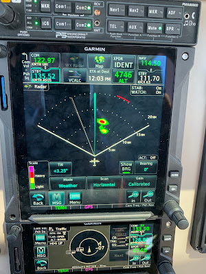
When I awoke this morning there were clear blue skies with storms off in the distance.  Yes they rumbled through later but around 9 AM they were just getting going.  You can see the big picture above (This is XM satellite radar which is delayed but produced by the large NWS doppler network), some near storms, some light rain starting around 50 miles, and some heavy storms out around 80-90 miles.  I headed West and approached the weather.


The close in rain looked impressive during my departure. It is about 40 miles out in the picture.  You can see it has some significant vertical development which makes a difference when using the radar.  Looking at the big picture above, you can see the near rain has 3 distinct parts and we can clearly see them in the image below.  The important controls on the radar are tilt and range.


The radar has a beam that is 8.4 wide and sweeps back and forth.  The beam, like a flashlight is stronger near the center but illuminates that 8.4 degree cone well and there is even some energy further out.  The tilt allows you to adjust where you point the beam and this is critical to accurately imaging the weather.  The above pictures shows the collection of cells clearly.  Given what I am seeing out the window and the returns, I would avoid this. Notice at 3.5 degrees, my central beam is clearly brushing the ground and I am getting a good bit of green ground clutter that is not rain.


Bumping up to plus 4 degrees, cleans up the clutter a good bit.  Notice the far tail looks like it is not as intense (it looked worse on the 3.5 tilt) but this may not be the case.  Since it is further back and I am tilted further up, it may be that my beam is scanning above the more intense rain.  At 35 miles there is not much drop off from the earth curvature, maybe 1000' but my beam is pretty wide out that far out, about 5 miles or 25,000' so I may be missing the important part of the storm.


Tilting up to 5.5 cleans up all the ground clutter but it also makes the rain look less intense than it is.  Lesson here, over tilting to eliminate all of the ground clutter is a bad idea. You are sending your beam into the top of the storm which is likely above the freezing level and will give you a false impression of the storm intensity.  When you are higher up this is less of a problem but you want to accept a bit of clutter to get the best weather image. 

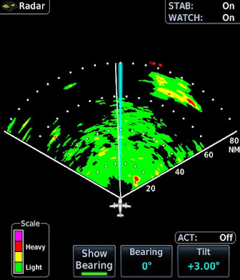
Looking out further, there were big storms at 80+ miles (see the first picture).  The easiest way to see that far is to drop your beam near the horizon.  The horizon is about 60 miles so at 80 there is not much drop off to hide weather.  You do need to keep your beam flat at that distance or you will send your energy over the storms.  You can see at plus 1 tilt the ground is covering the first 60 miles but we can clearly see the storms at 80 miles and the radar is warning with those red bars that there is more bad stuff off screen.  If you want to see in the 0-60 range, you will need to re-adjust the tilt for that range.


We can pick the bean up a bit to reduce the the ground and plus 3 seems to be a good compromise at this altitude.  We still have a good bit of clutter and we can see the near rain reminding us we will need to turn soon to avoid it. 


Tilting further we see that plus 4 is likely the limit of good. We can see the storms but we are making them look benign when in fact they are anything but.


Plus 5 looks cleaner still but is a mistake as you are losing too much information. Notice in the image below now that we have moved West and a bit closer to the tail of the near rain (it is only 20 miles), plus 5 is capturing the heavy precipitation and giving us a clean picture. Here is the plus 5 below, zoomed in.  When working less than 20 miles  or less, you can be more aggressive with the tilt.  This is also useful when making an approach over a city where you will get significant clutter which can be hard to differentiate from weather.


The far strong storms and the near storms imaged well but what about stuff in the middle?  There was a mass of light rain in the 40-60 mile range.  This did not look like much from the cockpit.  What did it look like on the radar?


Frankly it is hard to distinguish from the ground at plus 3 though the near and far rain in clear.  Tilting up to 4.25 cleans up the clutter but doesn't paint much.  We do have the throng storms at 70 miles that let us know we are tilted correctly to see anything big.  The reality is we need to get closer to get a better image.  At cruise speed I am still 12-13 minutes away with plenty of time to make a course correction depending on what happens as it moves inside 30 miles.


The clouds were starting to build so I made a strategic retreat.  This gave me an opportunity to use the radar to image the coast.  Pointing down we clearly see the coast.  The only odd return is the island that has grown off the mouth of the St. John's river.


We can bring the beam up a bit and look wider.  This is a better setting but still too low to be very useful for weather.  The coastline with all it's development reflects a lot of energy back.  The Red on the left is downtown Jacksonville and the yellow on the right is St. Augustine.


Our island is still there or is it?  Not really, there is no new land off the coast of Florida.  Just like buildings, large ships at sea are great radar targets.  The energy easily bounces off the side of a metal ship.   Below is a clearer picture.  There are actually 3 ships at anchor, each visible on radar.


On the left you can see the coast and just right of center is likely someone else's radar.  When another plane is is heading towards you and sweeps across your radar it makes a radial spike.  The radars are smart and use a variety of frequencies, the unit will adjust to ignore the other radar and they seldom show up for more than 1 or 2 sweeps.  Talking ships, below is a shot from Monday by Savannah.  The left is the coast, the right is more than 25 ships at anchor off Savannah.


I was ready to head in but the clouds had thickened a bit and were lower.  Approach was nice enough to provide a pop up IFR which avoided a detour around the clouds.  I joined the GPS 32, circle to land 23 as 32 was being inspected by FDOT.

Bases were 1,200' on the approach but much higher over the field.   It was a fun approach and I soon had the plane away well before the storms arrived.

Friday, July 15, 2022

A Gulf Low

Getting home always seems harder than getting there.  It could be that on the way out we have left a day early to pick better weather or used other strategies to make the conditions more favorable.  It could be that we always arrive home in the afternoon which is prime thunderstorm time.  It could be rotten luck, like the 30 knot headwind outbound and the 3 knot headwind heading home.


Regardless, getting home this trip presented a challenge.  I had been watching the weather but once out there is not much you can do to change things except wait it out.  So as I watched the low pressure move over the gulf, South of Louisiana, I knew that the afternoon might be a challenge.  Departing OKC was hot but clear.  I had another complicated clearance that included a VOR, radial and distance plus more.  Of course once airborne it was direct KLUBB intersection direct which was basically direct.

We headed back to HAB because the fuel was still the lowest price I had seen in a while and it had everything we needed.  2:45 later we were at the fuel pump after seeing mostly clear skies.  Technology is great and we had watched the mess over Louisiana, Florida, Alabama and Georgie get messier.  I was not really sure there was a way through but I figured we would fly up to the weather and at least get closer to home.

We launched into the blue skies and started watching and planning.  There were two lines, One ran from the gulf to the Atlanta area, the second ran from the gulf and curved around towards Amelia Island.  The first was looking good with a break at Auburn, AL.  The second looked like it may have a gap opening around Jesup, GA.  I had been watching the storm for 3 hours and it was racing North so the idea of trying to stay North of it and then South through a gap was not too appealing.

As we got closer I saw the rain in the panhandle was diminishing and I could get behind the weather.  This looked better and there were plenty of airports along the way I could use to divert if things did not go to plan.  The controllers were super helpful and clear me KAUO MAI  (Auburn and Greenville VOR).  

We were still in bright sunshine as we approached Auburn.  I had the onboard radar going on my MFD and the Satellite radar on the main GPS.  Auburn was a wall of clouds and with some deviations we made a nice turn and headed South.  The radar was showing just light rain it was not enough to really hear it but you could see it on the de-ice boots.

We continued South and broke out between gray layers.  It was sort of odd to go from a sunny day to dreary day in seconds.  We had about 100 miles to go before we were South of the rain.  Satellite was showing yellow all the way but the radar was showing mostly clear or green with a 5 mile band of yellow.

We went back into the soup and had pretty steady light rain with the 5 mile band of yellow still looming ahead.  I started picking up a few scattered pixels of red on the radar off to the right so we deviated a bit left and had about a minute of steady rain and then we were back out.  We were on the back side and from there we were able to stay dry and mostly VMC.  There were still some big cells but they were easily avoided.  

Approaching MAI I asked for direct Valdosta and after confirming the surrounding airspace was cold, was sent on my way.  The last big storm was over Valdosta and once we cleared it to the North we popped out again into sunny skies as if it had never happened.   We could see storms off in the distance and some pretty rainbows but the hard work was over for us.

I should say sunny skies except over JAX.  As we passed over downtown in bright sunshine, JAX had it's own personal rainstorm.  CC said it was like the cartoons where a character has a personal rain cloud.  It was a nice sight and I was glad it wasn't our problem.  We made a satisfactory arrival with gusty winds and soon had the plane away.

It was a flight of contrasts.  Busy and complicated departure from OKC followed by straight cruising.  Then we the best and worst weather.  I would not have attempted this in the Bonanza, the delayed radar is just not good enough when in close.  That said, the active radar is great within 60 miles and while you can  see weather farther, having the satellite for the big picture is also invaluable.  The combination let us traverse an area of severe weather weather with a mostly smooth ride and no more than light turbulence and light rain.  


Our route as flown.  The rain shown is not what we flew through.  It looks like it captured the rain picture around the time we turned South.  We did not fly through that cell by Valdosta, by the time we arrived it was smaller and well North.