
Thursday we actually got going early. We had been told the parking got tight at Bridal falls if you arrive too late. It wasn't quite true but being early we did score the first spot by the trail head. Ironic, that you care about how close you can park to the place you came to walk.

Telluride is a quaint yet stunning city. Imagine a valley with massive mountains on 3 sides. At the end of the valley, there is a towering waterfall so that pretty much wherever you are in town you not only see the mountains but also the waterfall capping off the view.

There are two ways up. One is a trail and the other is a switchback road suitable for high clearance vehicles. We initially started the trail but it was rather muddy from the previous days afternoon rain.

We switched to the road which was steep but easy. You gain 1368 feet on the way up. The only hazard on the climb is a small creek that you can hop from rock to rock to cross, or you can slosh through.


The climb is about 2.5 miles each way so it’s not bad. The waterfall is stunning and the road gave greats views along the way. Also there was a side waterfall which I think you only see from the road.


On the walk down we also did the road. At the stream I found what I thought was an easier way and glided across high and dry. CC splashed through but thanks to the low humidity, her shoes were bone dry a few hours later.


Our next hike was really tough because we could not find the trail head. The internet is usually great for these things and google maps has them marked most of the time. We knew about where it had to be but once we got close we drove past it and wasted a few minutes.


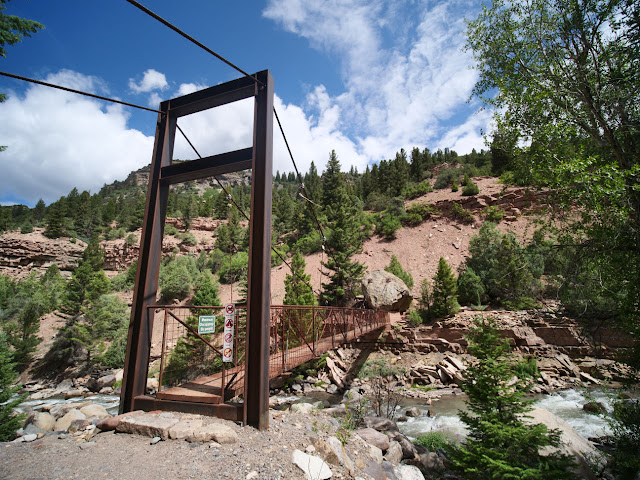
For the record the Keystone Gorge Trail head is just out of town off of 145 heading toward Cortez. Go behind the Conoco station and follow the road to the mountain school on the right.


The trail is a combo of 2 trails and starts flat and easy. You take a spur until you meet the loop. It goes West along the river, then there is a suspension bridge to cross over and then East back to a flat bridge. The loop is about 2 miles with a 500 foot drop and then rise in elevation. We did the clockwise route which I think was the better way. The trail was narrow but not too hard.

We found the Suspension bridge and enjoyed the river views. Crossing the river, the path became very narrow and had a steep drop off as it climbed 40-50 feet. CC did not like this portion and let me know it as only a wife can. Luckily the rest of the path while narrow, rocky and steep did not have sheer drop offs.

We worked our way back while my wife tried to convince me I had taken her on an advanced trail. The reality, the local rating was easy and the all trail rating was moderate. We have found that Colorado easy is not the same as the rest of the country.

On the way back from the gorge we dropped by the market and bought some food for lunch. After a suitable rest, our friends lent us some electric bikes. We rode them from town along the San Miguel river for a bit over a mile and then North to the main road. From there we headed into town and found the Ice Cream man.


When we arrived there was a long line but he worked fast and soon we had some massive cones which we made short work. The sky was looking dark so we returned the bikes and decided it was time for a break. The rain built just East of town today so in the end it never rained.

Around dusk the rain had cleared and we headed back to the gondola. We took the round trip ride again to watch the sun set and then see the town light up at night. Dinner was all the leftovers from the last few days. It seems like all we do is eat.

No comments:
Post a Comment