Tuesday, October 20, 2020

Water and Walking


We got a late start Saturday, sometimes it's nice to just take it easy. COVID had cancelled hot breakfasts but the hotel had grab and go. We scored got some fruit and snacks for energy boosts between hikes.  It was a chilly morning in the 40s but with light winds and our jackets we were ready to explore.


Our first stop was Todd creek falls just North of Clemson University.  You know you are near Clemson when you start seeing random tiger paws painted on the road.  Looking at the paw prints, those are some huge tigers. When we arrived we were parked under some high tension lines and there was no apparent trail. Usually there is a sign or something but not this time. I looked at my notes and the Google map and confirmed that we were in the right place so we decide to press on.


The trail did not exist exactly where the map said it started but as we walked along the road I saw a sliver of dirt surrounded by high vegetation. I declared this the trail and off we went. The trail averaged about a foot wide at best but it was apparent that we had found it. Little clues like a board left where it was especially muddy and foot prints gave us confidence.


The walk was short, about .3 miles and we saw the falls as we rounded a bend. We had to hike down some steep dirt to get a good view but they were really nice falls and for a bit we had them all to ourselves. I put up the drone and soon a family appeared at the top of the falls to photobomb my shots.  This seemed to be a recurring theme as people wanted to stand in the falls rather than look at the falls. 


The Bush was high and thick but it had some really nice wild flowers.  It also had lots of prickly things and dew.  We were glad that we dressed appropriately.


After beating our way out, we headed to Waldrop Stone falls. These falls were much easier. First there were other cars and one of those sign boards marking the trail.  The trail was wide and mostly flat.  It was a short hike but these falls were busy. There were some college kids that were everywhere and basically blocking my photography.


I put up the drone which was challenging as there were lots of trees. After getting my shots Irealized that somehow I had stopped recording so Iredid the drone shots. By then the college kids had camped out on the falls and a group of families with kids had invaded to crawl over all parts of the falls.


We sat off to the side waiting, watching the stream and eventually the college kids left. The dad then yelled at the kids to move and let me get some pictures. I thanked him and a minute later we hiked out.


Our next stop was not about waterfalls though we did get a bonus baby fall. We headed up to the Raven Rock trail which is on Lake Keowee. This was a 4 mile hike to see the lake.


Heading out it seemed deceptively easy but then we started downhill. CC reminded me of the first rule of hiking, when you walk down you will eventually walk up. We kept going and then the trail headed way up and down and up. The walk was nice and after 2 miles we got a nice overlook of the lake.


The leaves are also starting to change so we did have splashes of color. Regardless on the way back around mile 3 of uphill we were both feeling it. Around mile 3.5 I saw some trash on the trail. It turned out to be a nice cell phone.


It was on and charged but locked. I picked it up and trudged on I figured the owner might try calling it but nothing so we decided to take it to the rangers. The visitor center was just off the trail head. I was holding the phone out as I figured the owner might be looking for it. As we approached the ranger center two masked ladies saw us and asked if we had found that phone.


I placed it down and said if she could unlock it, it was hers. Like Cinderella and the glass slipper, this lady had the magic fingerprint and we headed off to the car for our next adventure. We had a quick ride North to Reedy Cove falls. The map did not work quite right and took us near the falls but was suggesting a private drive as the final street.


We had just passed waterfall road so I took a chance and headed that way. The road went from paved to potholes to dirt and and then one car wide but we soon found a parking lot and signs telling you not to climb the falls.  After seeing the falls, not sure why you needed a sign because it was obvious.


These falls were a short walk along a flat route, which was a welcome change. There was a small observation deck that was packed when we arrived but you could walk below this on the flat rocks next to the stream. These were rather impressive falls both in height and flow.


I sent the drone up again and got some nice shots. I then made a nice landing and while going to pick up the drone was distracted by a film crew trying moving in who were trying step on it. I slid on some leaves and ended up on my rear end. Luckily as I slid I sort of sat down and neither my body or equipment was damaged.


We took a few more pictures but it started to get crowded. It looked like they were going to do a video shoot as they were packing in bikes, tripods, gimbals and other equipment. We hiked out and started for home. The breakfast snacks were gone and it was almost 4 and we still had not had lunch.  CC was driving so I searched ahead for food. I found a Subway, Burger King  and a local BBQ place. We decided on BBQ. Technically this was the first restaurant we had eaten at since COVID. No we did not throw caution to the wind. You order outside and can pay by sliding your card from a distance.


They had 4 picnic tables outside well spaced. It did not really matter as we were the only people there. They had sold out of chicken so I tried the ribs while CC had the pork sandwich. I shared my cornbread and Mac with her too. No pictures of the food. I must have been hungry as I dove in before getting any. 


Having accomplished our last goal we headed to the hotel for some rest and to recharge batteries. We were not super hungry so dinner was some tacos and a burrito from Taco Bell plus some noodles leftover from Friday. We did well today with 8.5 miles of walking.  

Monday, October 19, 2020

Fall Adventure


Like most people our travel has been reduced but after the success of West Virginia, we decided to take a quick hop to enjoy the Fall weather.  Flying yourself means that some days the weather or other factors means it’s not going to happen. It also means you have a lot more flexibility. I originally planned a trip to Greenville last weekend but the hurricane remnants meant rain was in the forecast.


I decided to shift a weekend and it was a good move. The weather was last weekend was safe enough for us to fly but our plan was to hike the mountains and it is much more fun when not pouring and muddy.  Friday morning we did wake up to some fog so we took our time getting going.  Also a nice thing, you never have to worry about missing your flight. We do have to file a departure time but our window is 2.5 hours and we can easily reset the time when needed.  It was a hazy flight but mostly clear and smooth.


We rolled out to the runway around 9:20 and though we were initially cleared pretty much direct, we soon had a reroute around airspace the military was using for practice. It only added a few minutes and we were soon on the ground in Greenville. Our rental car was waiting for us and we managed to travel in a contactless manner.


Our first stop was Wildcat falls North of Greenville.  Parking is roadside and there is a nice path. It is really a double header as there are some small falls roadside.  The path is about .3 miles each way and after an initial spur it is a loop.  Both river crossings were easy but the flow was low.  The hiking was nice as the temperatures were mid 60s under sunny skies.


Our next stop was Bald Rock. This had an even easier walk. The rock starts about 20 feet from parking area. Bald Rock is a rounded mountain top that is, as the name implies, rock. People have been marking the rock with spray paint for quite some time.  I did read that this is bad, I did not delve into the details but assume it interferes with the local eco system and leaches chemicals.  I decided not to debate the philosophy and just enjoy the setting though.


It has a high school/hippie vibe but it has great Mountain View’s and some charm. It also gave me a chance to fly the drone a bit. After a short walk we continued up the road and stopped at Caesars Head for the overlook. The lighting was not great so we headed on.  I have yet to get a good view from Caesars head.  I am starting to think it is highly over-rated.


We had skipped lunch because the timing of our flight meant there was no meal service. The FBO has given us some snacks but otherwise we had focused on sights over food. Luckily as we drove on we spotted a Bojangles and picked up two chicken biscuits. It may have been the hunger but they were darn good. They are technically breakfast items but served all day.  Refreshed, we prepared for the last falls of the day.


Our final waterfall was Little Brady falls. It was also a short walk in but before we could get to the main falls, the path crossed the river. Ok maybe stream but it was deep and cold. We decided to stay dry and instead enjoyed the rapids and a baby waterfall.


We called it a day and headed to the hotel. We are still in COVID  mode so we stayed at a Residence in on the first floor. Dinner was Thai takeout that was contactless and we watched the free movies while enjoying curry and noodles.  

Friday, October 9, 2020

Florida Weather


I needed to head down to New Smyrna this morning. Thursday night the forecast was for rain all day so I was a bit concerned but my read was that it would be rainy but would have scattered coverage.  I set my alarm bright and early so I would be ready to go at sunrise.


At O dark twenty the alarm went off and as promised there was rain moving in.  Moving in was the key, I had time to get off and get out of town.  


Early morning flight would be perfect if I could do them later in the day.  I hate mornings but it is a great time to fly.  The temperatures are cooler, not much wind and it's not so busy.  Taxiing out there were wisps of fog by the ground which created a surreal look with the approaching storm. 


 I took off just before sunrise so as I climbed I created my own sunrise.  Heading South I had to stay at 1500 to stay below the clouds.  I had chosen to go VFR as there was rain on the departure and this way I could avoid it.


A bit North of Saint Augustine I cleared the last shower and was able to climb to 5500 under blue skies.  From their the flight was easy with Daytona taking me West of international.  It was a pretty morning and as I set up for an extended base to runway 7, I had a Honda Jet 900 feet below heading into Spruce Creek.


I was done around 10:15 and looked to my return.  The clouds had started to layer a bit so I had filed IFR.  Departing New Smyrna I got a turn to the South and then West.  Wrong way but it allowed me to climb outside Daytona's traffic.  Checking in with the second approach controller, she cleared me to 5000.  I was about to discuss routing as the direct route took me through a substantial storm in the area of Flagler.


She was ahead of me and told me to fly 300 and expect V267.  I was on top and could see the storm in the distance.  I asked for a 320 heading to join V267 and was cleared as requested.  Moving West took me around the bulk of the weather.  I joined V267 and headed North but there was one mean looking cloud ahead.


When you are IFR you are expected to fly in the clouds and I had done so on the departure but not all clouds are the same.  This cloud looked like part of the storm and was also growing vertically which is never a good sign.  I asked to avoid it and was cleared to deviate West.  A mile sidestep kept me out of it and I was soon heading direct home.


I got a good view of the rain as I passed.  I was glad I had taken the detour.  The arrival home was also a bit interesting.  Because of another airplane, the controller kept me at 2500 until 4 miles from the airport.  I was then given the visual approach.  It was only scattered clouds but once on the visual you must remain clear of clouds.  Of course the clouds were exactly where I wanted to go but a bit of maneuvering kept me clear and using gear and flaps let me make a steep descent.  

It had been raining which meant a wet runway.  Even though I was high, by the time I was crossing the 50 foot mark, speed was right on and I easily made the turn off at 1000 feet.  The plane was soon tucked away in the hangar and I was off to my next task.  


Thursday, September 24, 2020

Where's My Tailwind?

West Virginia was fun but work called so Monday morning we headed back home.  The forecast weather was supposed to be clear almost all the way and then 4000' or better.  We planned an early for us, 8:30 am departure to beat possible afternoon rain.  The one issue was the surface winds down South.  Forecast was 25+ knots from 050.


I chose Allendale, SC as our fuel stop.  We had used it many times before.  Nice runway, friendly service, cheap gas, clean facilities and candy on the counter.  The runway is 35 so if we had 050 winds at 25 that is a pretty strong crosswind.  There are also trees along the right side that would create a good bit of turbulence.  My backup was Barnwell, 19 miles North, 50 cents more per gallon but a runway aligned with 050.


Leaving Clarksburg, it was a ghost town.  It was 40 degrees so once I started I idled in place for several minutes to warm the engine and oil.  Then I taxied slowly to get to the operating temperature I wanted for takeoff.  We never saw another operation from our arrival at the plane till we departed.  Departure was easy as the runway basically put us on course.


I filed for 8000 to cross the mountains and because I was supposed to have a crosswind.  We initially headed about 220 and had a small tailwind.  We had to head South West to get around Charlotte.  Also by paralleling the mountains, it made our over mountain crossing shorter when heading South.  We were enjoying great mountain views with pockets of morning fog and a smooth ride.

When we made our turn, we lost our tailwind and picked up about 15 on the nose as well a a steady chop.  The forecast was wrong but it did say that higher was better.  I asked for and got 10 thousand and up we went.  As we climbed the wind shifted to our tail and dropped a bit.  We ended up with about 7 on the tail which was nice.


Coming into Allendale, the controller had another Beechcraft inbound as well.  He was having trouble finding the airport which I understood.  It is sandwiched between trees and I can find it now but the first time was also a challenge for me.  He ended up beating us to the field and I knew he would be heading to the pump too. I politely asked if he was, and when he said yes, requested that he pull up enough that we could park behind and fuel without having to move the plane.


He was very nice and agreed.  We had to wait for him to gas but enjoyed chatting with another fellow Florida Aviator.  Soon our tanks were topped, others drained and we had been given candy and water. We launched for the short 56 minute hop home.  We had been watching the weather and by the time we were crossing Savannah, we saw a small line of rain heading for home.  It looked like we could beat it so we pressed on.  Crossing Saint Simons we went from clear to cloudy and even though the ATIS was still calling for good VFR, the controller was saying that previous planes had needed an approach.


At first I was going to see if we could pick up the field visual but the rain was getting closer and our path would take us through some moderate precipitation so I requested the GPS 14 approach, circle to 5.  The circle was because we had gusty winds up to 25 knots at 050.  The 14 approach is not my favorite as it has a slight bend on final but it made sense today.


The controller gave us a direct to the initial fix and from their things went like clockwork.  Bases were at 1600 but even though we broke out, the rain limited visibility and we didn't pick up the airport until about 2 miles.  From their the circle was easy.  We had light rain on final as the showers started to show up.


Regular blog readers know I got soaked a few weeks ago after landing.  This time I expedited pushing the plane back and just beat the next set of rain.


Wednesday, September 23, 2020

Faces and Knobs


I was a bit tired by Saturday evening.  Over 3 hours of instrument flying Friday, hiking and a few hundred miles of really hard roads Saturday.  CC came to the rescue and offered to drive Sunday.  The morning was once again brisk as we headed to Seneca Rock.  I knew the first part was going to be easy since we started on I-79.


After 20 miles we took our exit and instead of a cart path like I had enjoyed, she had a divided 4 lane highway.  This continued most of the way until about 30 miles out where she got 2 lane with alternating passing lanes.  All was good though, we arrived alive and I got a break from driving.


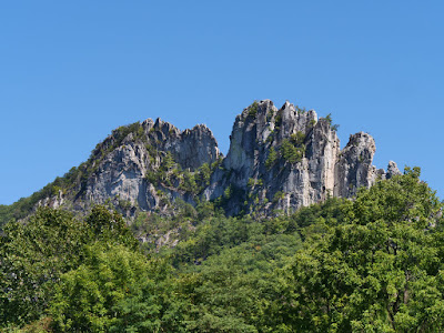
Seneca rock is a large formation that combines trails and danger.  The rocks have claimed 15 lives since 1971 and they have many signs to remind you.  Since I was being careful not to die of a virus, I figured that I should respect gravity too.  When we arrived the sun was behind the rocks and the view was nice but not spectacular.  


Frankly I was hoping to see some leaves changing.  The prediction sites said we should have some at the high elevations.  We were about 2 weeks early I figure with only sporadic dashes of color.  I'll chalk this one up to 2020.  


We did see some real mountaineers with ropes, helmets and climbing stuff strapped to them.  They left the parking lot in a different direction from us timid walkers.  I had come for the views and knew they had a nice 1.5 mile trail to an observation platform.  I should have read a bit more.


I figured the platform would provide a better view of the rocks.  Well not quite.  The trail started by crossing a pretty stream before gently winding through the forest.  It then started to rise and just kept going.  We trudged back and forth along the face of the rock.  It was nicely shaded by the trees.  


The observation platform is really next to the rocks that you came to see and lets you look out as if you had climbed the rocks.  In all you climb 836 feet.  We enjoyed the views, talked to some fellow hikers and decided to heed the do not proceed lest you die sign.  The way down was much easier. The first rule of trails is that when you head down, you will eventually have to hike up.  Luckily the corollary means that the up is going to followed by down.


By the time we returned to the car we were getting hungry.  Luckily there was a Subway down the road a bit and we picked up subs and drinks.  We held off eating though as we were on our way to Spruce Knob.  Spruce knob is the highest point in WV at 4,863 feet above sea level.  Why is it called a knob?  A knob is the top rounded part of a hill.  For some reason they have knobs and not mountains in WV.  

The drive was easy until the last 10 miles when we went to the narrow, can't quite fit 2 cars and really steep and curvy. We were soon on top and decided the first order of business was to eat. I must say it felt like we were camping.  We were outside and eating.  Yes, many of you will scoff but I can say that this is as close to camping as I will get.


It was cool and windy up on the knob, close to 50 degrees and we were glad we brought jackets.  We did see some locals in shorts but what do they know.  After eating we cleaned up and made preparations for the final ascent to the peak.  It was nothing like Everest.  You leave the parking lot and then walk about 700 feet across a flat trail to an observation platform.


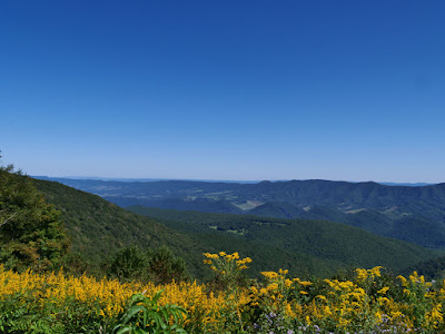
Two flights of stairs and you have a nice mountain view.  It works best to the West because trees block the East view.  It's a nice view and since you can drive there, worth the effort but it seemed a bit lacking.  We had a good time anyway taking selfies and admiring nature.


On the drive down we stopped at the East observation pull over which filled in the view.  Then it was time to head down.  By this time the Earth had rotated a bit and Seneca Rock was well lit.  We stopped for some pictures and then headed back to Clarksburg.


We were sort of tired of junk food so we chose IHOP curbside pickup.  They do a nice job and we were soon well fed.  I started planning the flight home and for a change the forecasts all looked good with the possibility of a tailwind.