Wednesday, August 4, 2021

1400 Miles To Go


I woke up before the alarm Saturday.  Something about embarking on a long flight makes me ready to get going.  We would have a bit more than 1400 miles to cover.  Heading East is made harder with the time change against you. Then there is that mythical super tail wind you are supposed to get.  We were wheels up at 7:15 but that was already 9:15 at home, so did we get an early or late start? 


Arriving at the plane it was drenched.  While the rain had mostly missed Durango earlier in the week, Friday night it had gotten a good soaking.  Luckily the plane does not leak and there was no water in the tanks.  We would be leaving at a mid weight with 111 out of 166 gallons on board for a take off weight of 4960.  The temperature was 15c which meant that we would have marginal one engine performance of 138 fpm climb and a decent engine out ceiling of 8900 feet. There was plenty of room to avoid the surrounding terrain.


The nice thing about Durango is that you have 9000 feet of runway. Taxiing to the end there was a regional jet blocking the taxiway so I asked his intentions and he was holding waiting for his IFR release. We go most places IFR but not in the mountains if we can avoid it. We would be VFR till Texas so when I was ready, I coordinated with the Jet to make sure I would not get in his way and then I took an intersection and back taxied. I had considered giving up the 1000 feet but nothing is as useless as the runway behind you...

Density altitude was 7,800' so acceleration was not brisk.  I had set 2000' as my expected 65 knot call out and we easily made that.  Take of roll was 25 seconds and another 8 to reach blue line.  At home we take 14 and 5.  Calculated Take off roll was 2380' and the computer data showed we took 2428'.  Close enough for me.  We reached blue line in 4170', one of the reasons I liked Durango was the fact that I had good margins just in case.  Thankfully everything kept spinning and all the calculations and contingency plans were not needed.

The weather model had predicted light headwinds becoming tail winds after Santa Fe and then a cross wind around Alabama.  Well that would have been nice, we actually started with 15-20 on the nose but we were early and on our way.  I had also hoped for clear skies to get some good mountain pictures but our clear skies were the same place as our tail wind.  Visibility was about 20 miles which was fine VFR, just not good picture weather.

Our first stop was HRX, Hereford Texas.  I had debated whether to make 2 or 3 fuel stops.  The way out was 2 but we had another 100 miles and we departed light on gas so 480 miles on the first leg would have been right at my comfort for landing.  Normally I would have been fine with less fuel on landing but we had taken partial gas at CYS and DRO so while I did in fact know to the gallon what fuel I had, I still am not confident in the calibrations so I am adding extra margin.


From Hereford we could have done 2, 3 hour hops but in the end we elected the extra stop to stretch our legs.  Hereford is a great stop, we had been before and it smells like cows, that's a bonus.  Inbound to an airport I am watching the runway and the other airplanes.  I miss some of the surrounding ground detail.  CC though was looking and noticed the massive feed lot with thousands of cows just West of the airport.  The mystery of the smell solved.

Leaving Texas we finally got our tailwind.  It was a hot day so we went to 11,000 where the plane sips gas at 12.2/side while cranking along at 189 knots.  Add in the tailwind and we were making 195-200, life was cool, smooth and good.

Our next stop was Durant Oklahoma.  It was a fast easy in and out stop with modern self serve.  The terminal was huge, cool and very nice but we did not linger and were soon back up in the tail wind.  We had been watching Mississippi all morning.  Lots of pop up rain and convective activity.  Our initial plan was Meridian.  We had been before, they have great service, some good food and it was on our route.  

We have also had to divert from Meridian due to storms.  Sure enough, Meridian had convection all around it.  We updated our destination to Greenville, Alabama.  It also had a small storm nearby but it was moving South and we were not arriving for another hour.  Everyone was deviating a lot and I thought we would have to as well.  Looking at the ADSB and active radar, I started to see a path.  I requested NOSRY intersection, then direct.

This took us 10 North of Meridian.  Unlike the way out, at 11,000 we were in the clear and we could easily see the convection towering up, otherwise we were above most of the clouds.  Our path took us by some rain but nothing big and passing meridian, the large storm had moved South but we could see it was still raining over the field.

Our arrival into Greenville was easy, there were some light showers that were easily avoided and we were soon on the ground enjoying the heat and humidity.  Again the equipment was good.  The FBO was deserted but the door had a code lock which happily accepted the CTAF frequency.  It was cool and clean inside which CC enjoyed while I fueled.

Our last leg home was a short 278 miles and we were in no hurry as we were early.  I dialed in 11.8/side which yielded 180 knots and we touched down around 6:15.  About 9 hours elapsed. There is an airline connection that does it in 5.5 but you need to leave at 6:15 AM and you have a tight connection and based on current reports are likely to get very delayed.  The more realistic one takes 7 hours.  In the end we did 1400 miles in 7.9 flight hours for an average speed of 177 knots.

The Bonanza was a great travelling machine but the Baron brings a level of capability and redundancy that makes travelling a good bit easier.  We are still not an airliner and there is a lot of weather that is beyond our capability but the added speed, range, radar and ice protection make a meaningful difference.

Tuesday, August 3, 2021

A change of scenery


Friday we slept in and then after stretching our legs, headed South to Mesa Verde.  The national park showcases, cave dwellings, early housing and spectacular views.  The drive from Telluride to Mesa Verde is striking both in beauty and the rapidly changing environment.  We had seen the rolling plains of WY, the Granite mountains and then off to Colorado for the towering 14,000+ foot forested peaks.


We were heading down through the foothills which back East would be towering mountains to the plains.  These plains were unlike the Wyoming ones with the thin grass cover.  These were more high dessert plains studded by mesas that long ago people crafted into houses.


Mesa Verde is huge, you drive 20 miles past the entry booth before you get to the first house.  The park offers tours of the cave dwellings but you need a reservation and because of COVID, they were not offered.  Right now the park is a self drive self tour.


You start on a loop road with pull offs every 500 yards.  They range from an archeological site of pit houses to views of the cliff side dwellings.  They are actually houses built into the cliff face. I think we would have been more disappointed about not getting up and close with the dwellings if we had not visited Bandelier where you can climb the ladders and enter the cave.  


We had also been to Walnut Canyon where you can’t enter the dwellings but you can go to the front doors and look inside.


After completing the loop we started to head back the 20 miles.  On the way in we had skipped all the extra stops and overlooks.  This was strategic.  We wanted to get to the popular stuff before it got too crowded and hot.

On the way out we visited a tower or what was left of it and then an area of ruins.  Unlike the earlier area, one set was designated for you to enter.  We also saw a reservoir, other houses and some more advanced structures.


We then stopped at all the overlooks which broke up the 20 mile drive nicely.  While we were touring, a thunderstorm had formed North of us.  Each stop it was creeping closer and by the last stop the lightning was getting too close for comfort so we were happy to finish up and head for Durango.


When we got to Durango we grabbed some food and then dropped by the plane.  We had flown 10 hours and the engines looked like they had used a bit of oil.  I put a half quart in each just to be sure I would not need to add any on our flight home.  We also dropped a few things at the plane we would not need overnight and I did a preflight to hopefully forestall any morning surprise.  All looked good but the sky once again had turned dark.


We took a leisurely drive to the North of Durango to see a park.  It was quite nice and had cows grazing across the river.  The rain started to come so we headed for our hotel.  On the way we spotted 5 stags crossing the road and stopping to graze for a bit before bolting off.  


Dinner was BBQ we picked up on the way back.  I spent some time reviewing the plan for our return, filing flight plans and checking weather.  The forecast seemed too good with the only issue being hot temperatures at our fuel stops.  So far we have stayed relatively cool on this vacation while it was roasting back home.  Saturday was looking like a scorcher though.


Monday, August 2, 2021

Doubling Down


Thursday we actually got going early.  We had been told the parking got tight at Bridal falls if you arrive too late.  It wasn't quite true but being early we did score the first spot by the trail head.  Ironic, that you care about how close you can park to the place you came to walk. 

Telluride is a quaint yet stunning city. Imagine a valley with massive mountains on 3 sides.  At the end of the valley, there is a towering waterfall so that pretty much wherever you are in town you not only see the mountains but also the waterfall capping off the view.


There are two ways up.  One is a trail and the other is a switchback road suitable for high clearance vehicles.  We initially started the trail but it was rather muddy from the previous days afternoon rain.

We switched to the road which was steep but easy.  You gain 1368 feet on the way up.  The only hazard on the climb is a small creek that you can hop from rock to rock to cross, or you can slosh through.


The climb is about 2.5 miles each way so it’s not bad.  The waterfall is stunning and the road gave greats views along the way.  Also there was a side waterfall which I think you only see from the road.


On the walk down we also did the road.  At the stream I found what I thought was an easier way and glided across high and dry.  CC splashed through but thanks to the low humidity, her shoes were bone dry a few hours later.


Our next hike was really tough because we could not find the trail head.  The internet is usually great for these things and google maps has them marked most of the time.  We knew about where it had to be but once we got close we drove past it and wasted a few minutes.  


For the record the Keystone Gorge Trail head is just out of town off of 145 heading toward Cortez. Go behind the Conoco station and follow the road to the mountain school on the right.


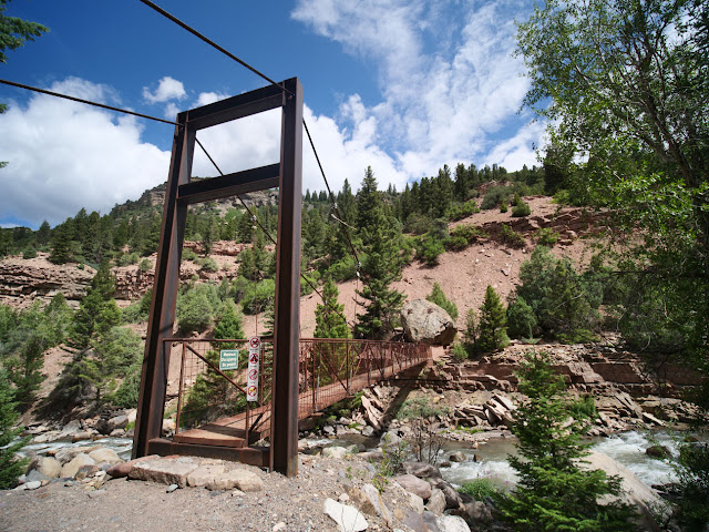
The trail is a combo of 2 trails and starts flat and easy.  You take a spur until you meet the loop.  It goes West along the river, then there is a suspension bridge to cross over and then East back to a flat bridge.  The loop is about 2 miles with a 500 foot drop and then rise in elevation. We did the clockwise route which I think was the better way. The trail was narrow but not too hard.  

We found the Suspension bridge and enjoyed the river views.  Crossing the river, the path became very narrow and had a steep drop off as it climbed 40-50 feet.  CC did not like this portion and let me know it as only a wife can.  Luckily the rest of the path while narrow, rocky and steep did not have sheer drop offs.  

We worked our way back while my wife tried to convince me I had taken her on an advanced trail.  The reality, the local rating was easy and the all trail rating was moderate.  We have found that Colorado easy is not the same as the rest of the country.


On the way back from the gorge we dropped by the market and bought some food for lunch.  After a suitable rest, our friends lent us some electric bikes.  We rode them from town along the San Miguel river for a bit over a mile and then North to the main road.  From there we headed into town and found the Ice Cream man.  


When we arrived there was a long line but he worked fast and soon we had some massive cones which we made short work.  The sky was looking dark so we returned the bikes and decided it was time for a break.  The rain built just East of town today so in the end it never rained.


Around dusk the rain had cleared and we headed back to the gondola.  We took the round trip ride again to watch the sun set and then see the town light up at night.  Dinner was all the leftovers from the last few days.  It seems like all we do is eat.