Sunday, November 28, 2021

ATC Mischief


We had a lot of fun in Miami.  Yes we ate too much turkey but I also got to show my Dad the Baron and take a nature hike with the kids.  Heading North I figured I would get a new routing based on our trip down.  I was again surprised when I filed ARKES TRV V3 OMN and the computer said that's what I'll get.

When I called ground, he informed me that the computer had my expected route but he couldn't give that to me. the ARKES departure was no longer allowed.  I had to either file the Miami 8 or to SHANC.  He said I needed to refile, he couldn't do anything.  Usually the computer generates a new route if you file something it doesn't like or the controller will update it if they don't like it.  I was a bit taken aback, I have never been told that it is my problem to fix it or to re-file. 


Re-filing is not a big deal so I tried to take a shortcut. I filed HWO CRG. Usually the computer chuckles and says yeah right and puts in the correct route. Today it cleared me direct, maybe it was in a good mood after eating a bunch of turkey.  Ground called to tell me this and said no way... He also said I needed to file T208 after SHANC. Armed with a bit more knowledge and now familiar where they wanted me to go, I said give me a minute. I filed SHANC T208 SUUGR which the computer and ground liked and we were soon on our way.

Miami is getting interesting, for example to get our departure I needed to accept the Sheridan departure which is only found on one FAA website and as far as I can see not officially published.  Too many FAA secret handshakes if you ask me.  Also looking at it all again safe at home, the Miami8 is not very useful North bound as you are supposed to head over one of the VORs to the South (there is one over FLL but it then turns South). Also SHANC is not on the Miami8.

How are you supposed to know about the secret fix to file? I get it when you file your fantasy and the computer gives you reality. In this case the computer gave me what I filed but it is no longer usable?  The irony is that the final route is almost the same as the one I filed.  Just new fixes and names along the way.

Saturday, November 27, 2021

A New Way


I have been flying to South Florida since at least the late 90s. You can file whatever route you like but for years it was a sure thing you would get OMN V3 MLB V437 BRIKL. basically down the coast to a Melbourne and then over the East edge of lake Okeechobee and then an intersection about 20 North of Miami.  This route kept you out of the Palm Beach and Fort Lauderdale traffic as well as under the big iron inbound to MIA. 

A few years back they got cute and changed it to OMN V3 TRV V51 PHK V437 BRIKL. This had you continuing 20 more miles on the coast before you headed to the lake. The odd thing is the computer had this new idea but every time I flew it, passing MLB I would be cleared to PHK which basically meant that even with the new route, you were still flying the old one.  

I was a bit surprise when I filed and got this: FOXAM T208 DIMBY LLNCH T345 MARKT. We are now in the GPS world and Victor airways seem passé to the computer. T routes are all the rage and defined by GPS not VORs. I was still unsure what I would really get, he computer has told me to expect one route and come time to copy my clearance and I get something else.

It’s sort of sad to not end at BRIKL. Mary and William Brickell were early Miami settlers that set up shop 150 years ago (1871) on what is now SE 5th and Brickell. Originally a swank area for the rich and then in the 80s a place for condos no one wanted, it is once again a playground for the young and a rich with great views and wall to wall condos which are highly sought after.

Tuesday was chilly and windy. As we warmed the engines I called ground and they gave me the new route, go GPS. on departure we got the standard 100 heading and departure gave us 10,000 before we got to our initial 3000 level off. Regular readers will know that we bucked 40 knot headwinds on our last trip. Today we had up to 40 on the tail. Yes a tailwind really does exist.

We also had mostly clear weather with just a few clouds offshore. The visibility was close to 100 miles looking down the coast but as we neared our destination there was some smoke off to the East.  As usual they made us come down earlier than I like but we still had 20 knots on the tail and with the new route, the controller let us go from MARKT direct FRDDY which is the initial to GPS 10R. 1R was in use so we expected a circle to land. As we turned final, we were at 2000, the plate had us maintain 1600 until the next fix but the controller gave us 1500 for traffic. This was a bit odd. as once you are on an approach you should follow the altitude guidance of the plate.  The controller can take you lower on vectors but then you are not on the approach.

I had the runway in sight so I asked if we could switch to the visual.  We were cleared for the visual which cleared up the altitude ambiguity and let us miss the other traffic. The wind was mostly down the runway at 15 so landing was easy and we had no issue turning off at our preferred taxiway at 1700 feet. We could have easily made the one at 1200 feet. I’ve been practicing. 

Friday, October 29, 2021

Headwinds (Nuff Said)


We had been very lucky on the weather. The week before, it had been rather soggy and next week was shaping up to be a soaker in the North East as well. We had enjoyed blue skies everyday with only a quick shower Tuesday night and Thursday night. The forecast was for an overcast layer on departure but Forecasts are just guesses and my gut told me we would have nice weather for the way home except for the wind.  

All week I had been watching the Jet Stream dipping South and it was going to be something to complain about.  Our expected clearance had a bit of a detour West, but actual clearance had us joining the airway in a direct manner. Our first destination was Blue Ridge airport. We had used Martinsville, VA as a fuel stop before when we were flying to Charlottesville.  Good runway, cheap gas and friendly people.  I also really like the airport identifier, its MTV, how cool is that.

Why stop, the plane holds enough gas to get home but the gas at Harrisburg was on the high side so I just bought enough to meet the minimum to wave fees and a bit more to have generous reserves, remember we had left New Jersey light due to the short runway.  Back to the route, the direct route took us very close to the Camp David prohibited area and the Washington DC special flight rules area.  The chance of letting us bust through was low so a gentle detour over Hagerstown VOR would make everyone happy.

Initially the winds on departure were a bit better than forecast. We had no headwind.  This did not last and soon we saw the number start to climb. I had filed for 6000 to try to stay below the worst of it. I would have gone lower, but the mountains made 6000 the minimum safe choice.  The views were great, and we made it down to our stop in 1:36 which was only 7 minutes longer than a no wind time.  During our descent we had a preview of things to come though with 30 knot winds.

MTV did not disappoint. The computer estimated we would take 98 gallons. One issue with the Baron is that the larger fuel orders take longer to pump. A few weeks back I suffered through a painfully slow pump at New Smyrna that pumped at about 6 gallons per minute. The MTV pump almost had the opposite problem, it seemed to pump close to 25 gallons per minute, it had quite a kick and I had to be careful to not use full speed as I neared topping each tank.

The departure from MTV was smooth and we were soon climbing into the worst of the headwinds. I had filed for 8000 to keep us out of a cloud deck and because the winds were basically the same at 6000. This was confirmed later in the flight as we heard reports from other nearby aircraft.

Charlotte had no love for us as well. I had filed the airway which you are supposed to use to stay out of their way and in their wisdom, they assigned us one a bit further East. I had hoped that the winds would be more cross and less head. You can hope all you want but through most of the Carolinas we had 30+ on the nose, I snapped this picture with 39 and I believe it peaked at 41.

This is when the extra speed of the Baron really shines. The Bonanza topped out at around 170 but in the Baron I can easily push it up to the mid 190s, I dialed in 192 which meant we were making at least 150 knots even with the headwinds.

We eventually worked South of the monster winds, and they diminished and became more of a crosswind and  from Savannah home we had less than 10 knots. We had mostly stayed above the clouds but on our last segment had fun darting in and out of the puffy buildups. Our arrival we easy with a straight in to 23 and a quick taxi back to the hangar. 

The direct no wind route without stops should have been 3:35, it took us 4:06 or 30 minutes and 20 gallons more than planned. We had had more favorable winds most of the trip and I had burned about 10 gallons less than planned so the net was 10 extra for the trip.  We had enjoyed  perfect weather for our sightseeing so the scales balance. Overall another successful adventure.

Thursday, October 28, 2021

Not So Brilliant

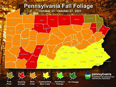
Our plan for Pennsylvania was to do some leaf peeping.  PA is known for their leaves and last year was supposed to have been pretty stunning.  I had planned our destination weeks out so we knew we might have to go North or South to see the peak.  I had been watching the state and media reports for the last 2 weeks and it looked like we nailed the timing.  "Nailed it" may have been the proper description.


Flying in we only saw a smattering of color but the report said it was there, we would just need to drive a bit.  We have the official report above.  In the end I think today was more about the journey than the destination.   We headed towards State College with the plan to continue to Black Moshannon state park about 30 miles North if required.


As we drove we saw more and more splashes of color but we also noticed that we had a quarter color, a quarter no leaves and half green.  State college was nice but not there so we headed to the Park.  Again, nice views but not stunning.


We enjoyed the park for a while and decided we might do better heading a bit North East. This would also give us new views on the way back and take us through Amish country.  We headed towards Lewisburg and stopped at two other parks on the way, RB Winter and Sandbridge.  Again just splashes, we would occasionally see some really nice trees and a few by themselves were vibrant but the forest was not.


Our journey into Amish country was fun, we started to see more watch for buggy signs.  We had seen a lot of watch for deer signs and as many deer on the roadside that obviously did not see the watch for car signs.  Thankfully the only Buggies we saw were moving and safe.


We may not have gotten the perfect leaves but we did find a neat place for ice cream on the way back.  We enjoyed sitting in the shade on a nice autumn day.  We made it back to the hotel before sunset and had some local Stromboli for dinner.  I looked over my flight plans a few times seeing if I could optimize the route any way but there were not better altitudes or routes for what nature had planned for us.

Wednesday, October 27, 2021

A Trifecta (#25 Delaware, #24 New Jersey, #23 Pennsylvania)

We took 3 states off the list today. Delaware was 25, New Jersey 24 and Pennsylvania 23. We got a early start today and were on the road by 9. We had topped off our Prius rental the day before and had only put about 60 miles on it since. We stopped to top it again before returning it and it took less than a gallon.

It was quite fuel efficient but not very quiet. I just need to figure out how to get the same fuel efficiency in the Baron. Departing Salisbury we had an important task. We had sightseed Delaware but had no landing, so we did a quick one at Delaware Coastal airport. Once that formality was completed, we headed Northeast to cross the mouth of the Delaware Bay.


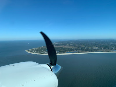
It was fun to look down and see where we had been the day before. We also saw Delaware’s wind turbine. Crossing the water we went feet dry over Cape May and proceeded North up the Jersey Shore. I did this flight VFR which is odd for me when we are outside our local area. I had a reason though, in the busy airspace it made it easier. We also wanted to stay low to sightsee.

We had a great view of Atlantic City from just offshore at 1300 feet. We then proceeded North a bit to avoid airspace and headed for Central Jersey airport. 47N is a pretty tight airport. Trees at both ends and on paper 3500x50 feet. Practically it was 3100 with the over-run because of the displace threshold. I have been practicing and easily made the turn off at 2000 feet.


We had come to Jersey for lunch which meant parking for a few hours. We were directed to transient parking but all that was left was a tight space in the corner. This meant spinning around and shutting down pretty far from the space. To make things worse the space was uphill and when we got out the plane wanted to roll forward.

We got some chocks under the wheels and I enlisted the help of my friend to push the plane uphill. The parking job was not my best but the plane was out of the way and not blocking any other aircraft. Once secured we headed to lunch. We had a good time catching up and ate way too much including some very good mousse cake.


Our friend dropped us off at the airport and we prepped the plane for the flight to Harrisburg.  It's not enough to be able to squeeze into an airport, you need to get out too.  We effectively had 3300' of pavement for departure.  The book said it would take us 1470' to reach lift off, if I had an on runway abort it would take 2950' to accelerate and stop worst case.  In theory, once you lift off, the test pilots have proven that the plane will climb if you immediately feather the bad engine.  The calculate distance to reach 50' was 4700'.  

That's the perfect world and today the airport fence was at 3500' and the trees start at 3900'  No they may not all be 50' but you start to see this is pretty tight.  I am also not a test pilot so I likely won't be as sharp and quick as the book assumptions.  This means if I have an engine fail before liftoff I have enough room to stop.  I am confident that once the gear is started up, which happens around 25-30' and after I have accelerated a bit more, I will be able to safely climb out on one engine.


Looking at the computer data, we took 1450' to hit rotation speed, right on book prediction.  It took 4 seconds to reach 100 knots (Blue line - best rate of climb single engine) and we had travelled 2075'.  What this meant is that there were about 2 seconds during the departure where losing an engine would have likely resulted in damaging the plane on the abort.  

I had looked at all these numbers before attempting the field.  While I have trained hard to be able to consistently land consistently in a short distance, with a light twin the departure requirements almost always exceed the arrival.  The biggest thing you can do to stack the deck in your favor is to be lighter.  I had arrived in Jersey with about half tanks which meant buying more  expensive fuel in Pennsylvania for the first leg home.  I love to score cheap gas  but I love to be safe more.


The trip to Pennsylvania after the departure was beautiful.  The sky was blue and cloudless and I elected to go VFR again at 4500. The weather has been very good but we did have to suck up a 20 knot headwind most of the way and a good bit of turbulence. This was a harbinger of things to come.  Our arrival into Harrisburg was easy as I was vectored behind a regional jet for a long straight in.

We flew 2 dots high on the glide slope to stay above his wake and touched down after his touchdown point. It’s a 10,000 foot runway so plenty of room. The FBO is Avflight, the same as we visited in Durango and the service was excellent again. Our car was even waiting for us, a Camry this time which we did not love but was better than the Prius.

Tuesday, October 26, 2021

Delaware is not just for incorporating

We did no better getting going Tuesday but we were on the road before 11, not much but before but on the road. We headed North up the shore and crossed into Delaware. Not much difference crossing the state line but the buildings seemed shorter.

Our destination was Cape Henlopin State park.  Park entry was $10, double the in state rate of $5. I have mixed feelings about this, I get that we don’t pay state tax but our state parks don’t charge Delawareans more, so why do they charge us?   Additionally I had to pay a machine which would be fine but the machine did not even provide a park map for my money.

Our first stop in the park was the observation tower. It was technically a fire control tower. During WW II, the area was used by the military and this tower was part of a network used to identify targets and provide range and location. After enjoying the views, we headed down to look at the old military installations and some artillery pieces.

While on the tower we saw a single wind turbine in the distance. It was quite odd to see one of these giants alone. The only thing I could surmise was that Delaware is quite small and this one turbine was sufficient to power the state?

We Drove to the South end of the park and enjoyed the beach views and then headed to the Beach Bathhouse. It’s a bit of a misnomer as it is really a shower house. They had bathrooms, showers and changing stalls. Pretty nice setup for a day at the beach. They also had a concession stand which of course was closed for the season.  We took a quick beach stroll and mostly had the beach to ourselves.

We again had no issues with traffic and parking as the season is done here as well. I don’t quite get it, the temperatures were high 60s and sunny. Why is October shunned?

Our next stop was the Hawk watch. This is a platform where volunteer birders watch and count migratory birds. We had seen a bald Eagle while at the Beach, this is just one of the birds they count. They eagles are becoming much more prevalent. We had actually seen one leaving our house and another while on final to our North Carolina stop.  Good to see such a strong comeback.


Our final park stop was The Point which was the inlet to Delaware Bay. Done with the park we headed back on the inland route. We went from marshes to cornfields and forests. We stopped at Millsboro, DE and picked a local sandwich shop to grab lunch. Both the Italian Sub and the Club Sandwich were filled with ample amounts of meat. We sat at a local park and dined while watching the birds in the river.


We decided to return to the inlet for sundown. CC thought the day before was prettier with some scattered clouds vs. clear skies. The wind was also up and it seemed colder as well. 


The Boardwalk had  less open stores but we enjoyed the sunset and the moon rise. After that we grabbed dinner and called it a day. Wednesday we were heading back to the sky and we had bug plans.