Tuesday, October 8, 2024

Arches and Canyons

We had come to Moab for Arches National Park.  Arches is a very popular park and they instituted a timed entry system to manage the crowds.  I forgot to get a slot month out and when I went online the earliest slot available was 11AM.  Luckily there is a second chance for people like me that forget to get a slot.  They only give out about 60% of the slots initially and the night before they open up the rest.  We were able to update our reservation to 9 AM.  

The park also allows open entry between 4 PM and 7 AM.  We took advantage last night and went in at sunset.  Our hotel is only a mile from the park so it is an easy drive.  The colors of the sunset were well worth the drive and after a drive we stopped at balanced rock.  We made the short hike at twilight and then sat out and chatted with other travelers as the skies darkened and the stars emerged.

We started our official park day in the morning.  I was a bit skeptical of the entry slot program and was worried that the park would be too crowded but the program works.  Parking is limited throughout the park but we were able to stop everywhere we wanted and always found a space.  We entered at  9:15 to avoid the punctual people and took only about 2 minutes to get through the gate.  Then we went sightseeing.  Park Avenue is an amazing canyon with views of Courthouse Towers.  We stopped at both for the views.

We skipped balanced rock and headed out to Double Arch, Window Arches and Turret Arch.  These were great, for less than 2 miles of hiking you get 5 arches plus lots of scenic views.  Our timing was lucky again.  The people around the arches ebbs and flows and we happened to get to them with few other people around.

We also picked up the Garden of Eden.  Not sure why it is so named but it was very picturesque and we made an easy climb through some nice rock formations.  Moab was supposed to be hot, upper 80s but the temps were much cooler in the morning so it was quite refreshing.

We then headed to the back of the park to see some more arches.  The hikes here were a bit harder and we opted for the easier Tunnel Arch and Pine tree Arch.  This area was more crowded but was not mobbed, maybe the system works.  Also without crazy mobs, it seemed the people were more relaxed.  We met and chatted with several people along the way.

On the park's back side we took two more short hikes to Skyline Arch and Sand Dune Arch.  Sand Dune Arch requires you to walk through a narrow passage and then trudge through fine silty sand to the arch.  It was much harder to hike on the sand but the arch was nice and the shade was refreshing.

It was afternoon by now and it was getting hotter.  We were working through our water so when we got to the Delicate Arches we chose to take the short observation walk rather than the multi mile climb to see them up close.  We had hit all the trails we had planned and a bit more so after about 5 hours we headed out to get some tall sodas and food.


We waited for the temperatures to start abating and headed back into the park for a few more hours.  We picked up the hike from Courthouse Towers through Park Avenue.  We did about 75% of it stopping when it started its more aggressive climb.  We then went back to Balanced Rock to get the view in a better light.  It was pretty empty and we climbed the base to watch the sun set.  It was a great perch with a nice breeze and we watched the shadows grow along the desert floor.

As the sun dipped below the horizon, the temperatures dropped and we headed back to let the skies darken.   We were not done yet though, Arches has good dark skies, so we headed back in one last time and parked by Park Avenue.  After a few minutes our eyes adjusted and we were rewarded with the stars.  Not the few bright ones we see at home, billions upon billions of them.  We could even see the milky way.

We made a great decision and slept in the next day.  Our goal was Canyonlands National park.  The park was just 30 minutes down the road and we made it to the gate around 9 AM.  Once again the park was not too crowded and while spaces were not always plentiful, we did not have to spend much time finding one.  This park has some nice short hikes and many brutal long ones.  Yesterday we walked around 8 miles.  Today we were less ambitious.

Ironically our first stop was Mesa Arch.  Yes, yesterday was Arches, today is canyons, yet we went to an arch.  Mesa Arch is small in comparison to the others but it frames a view of the canyons that takes your breath away.  Pictures were hard when we arrived because there were quite a few visitors but as we were hanging out, they headed off and we had some great quiet time with the views.

The rest of the park is all about the Canyons and a bit about Buttes.  I've said it before, I like big buttes.  We went from stop to stop enjoying overlooks and making a few short hikes.  We spent about 4 hours in the park.  The temperatures were initially cool but the high was 88 and as the afternoon progressed we could feel the heat.

In the shade and with a breeze it was actually quite nice but in the sun it was warm.  Canyonlands is a great park but since it is right by Arches, it seems to get less love.  I must admit, even though I don’t have an Instagram account or use the App, we did some very Instagramy pictures.  If I was only a lot cooler, I could be an influencer.  I am guessing I am in the wrong demographic for that line of work though.

Our last sightseeing day on our trip, we planned to take it easy.  More driving, less hiking.  There is an iconic loop road we planned to take but the loop was interrupted.  This was the third loop road that was closed on our trip.  Once again we had to drive in and out but it was a spectacular drive.  We started by following the Colorado river and then headed up into the mountains.

The views were astonishing.  Tall canyon walls, flowing water, blue skies.  We then turned off the river and headed through a canyon.  The greenery surrounding the river melted away to expose the red soil and striated canyon walls.  As we progressed further and climbed higher into the mountains the terrain suddenly changed to a more forested mountain landscape.  

We arrive at a small pullout, Bull Canyon Overlook.  The literature said we had a short trail, so we booted up but it was much shorter than I thought.  A few feet from the parking lot we came upon our first prize.  Locked in the rock were dinosaur footprints.  A three toed beast.  


After admiring the talon prints, we received our second prize.  There was an amazing view of the canyon.  The drop offs were sheer and terrifying so we stayed back from the edge.  We followed a short path along the edge, for more spectacular sights.  We also had great views of the beginnings of fall.  The colors were starting to change on the mountain.  We were over 8,000 in elevation and had a close view of the mountain peak.

On the way down we stopped along the way to snap pictures of cool rock formations and enjoy the scenery.  We eventually came back to where we started just a mile from the hotel and headed South through Moab.  We had one last arch to see.  Wilson Arch was 28 miles South and can be seen from the roadside pull out.

The trail up is a bit rough and the boots came in handy here.  I did not go all the way but did ascend to just before the arch.  The views were striking and it capped off our Utah adventure.  The temperature was rising again so we decided to take it easy.  I did want to make sure the plane was ready for our flights home so we dropped by the airport to clean the windows, check the fuel and oil and get everything set up.  We also loaded all the junk we no longer needed so we had less to do in the morning.

We had one more hike in us and as the sun was starting to set, we headed onto the Moab Canyon Pathway to walk over the Colorado river.  The flow seemed anemic and I thought that all those people down in Southern California are getting mighty thirsty.  Regardless, it was a nice stroll and the bridge over the river was nice.  Time to pack up and file some flight plans, we need to be in the air early in the morning.  The Hurricane that we were watching, became a major and is slamming into the bend of Florida but should be out of our way by the time we arrive.


Monday, October 7, 2024

And then there was one (#3 Nevada, #2Utah)

The Truckee departure is interesting.  The morning was interesting.  We showed up a bit before 8 AM to prep the plane.  It had been cold overnight, when I got to the plane it had dew on it, no issue but as I climbed the wing the dew looked more like frost.  Sure enough the top of the cabin was frosted.  Frost is a no go so I started by walking around and checking the surfaces, luckily the rest of the plane just had dew.  After preflighting we dropped our car off and then fired up.

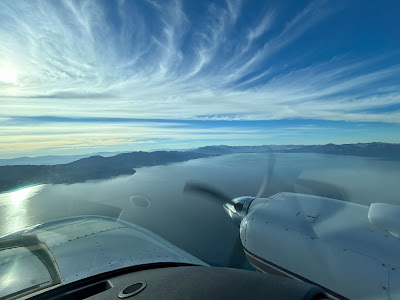
We took off runway 29 which requires a gentle right turn and then a left turn over I-80.  Once you reach Donner Lake, hard left and overfly Tahoe city.  If something goes wrong, staying on the precise track is important because it allows you to avoid the terrain and reach a runway at South Tahoe.

Luckily, everything worked as advertised and we easily climbed to 9,500' feet to clear the Mountains West of the lake.  We were VFR with flight following again to allow us the ability to stay at non oxygen altitudes and to take a more efficient route.

Our first stop was Tonopah Nevada.  This would serve two purposes, we would cross Nevada off the list and we would tank up.  The fuel at Moab was pretty pricey so it made sense to get some now.  Also unlike Tahoe, it is flat around Tonopah so an engine failure at the higher weight would still allow us to return to land.

The place had mixed reviews so I had called on Thursday to confirm the stop.  They assured me they would be there.  We touched down and pulled onto the ramp which was a bit of a wreck.  There was no apparent pump but there were some hoses strewn about.  We shut down by the hose and walked up to the lonely trailer.  It was locked and other than a cat staring at me through the window, unattended.  The place had a strange vibe, it even had a phone booth with a wired phone.  

I called the number on the door and the person said they had gone on an errand and would be back in 20 minutes or so.  I had my doubts and we had gas so I called an alternate airport on our route and confirmed they had gas and were open and off we went.

Other than the weird FBO, the flight had been amazing, we enjoyed the terrain and views.  The plane did complain a few times.  There was no wind so we were able to fly near the terrain.  The plane does not like when you fly by a peak, it yells at you and flashes lights.  We had 2 terrain warnings but in both cases we had planned the route and had lower terrain to turn towards if needed.  It is reassuring that it is looking out for you.

The alternate fuel stop, Richfield, was in a valley between two sets of mountains.  We followed I-70 through a gap and aligned with Richfield Runway 01.  At 5,300’ elevation, the indicated approach speed stays the same but true airspeed is higher. With 7,100' of runway, I was not concerned with having enough room.  We made a nice touchdown and taxied up to the pumps.  These were modern/fast and we were soon fueled.  I didn’t top off as we needed to watch our weight but I bought as much as my calculations would allow.  Technically this marked off Utah as we had landed but we continued on to Moab for our planed sightseeing.

The flight to Moab was short, A quick climb in the valley to top the pass and then a right turn direct.  The wind was just a few knots but it was getting warmer and later in the day.  Our previously smooth ride turned into a light chop  but the flight was only 40 minutes so after a very short cruise we were descending into Moab.

The arrival was smooth but finding the correct parking was a challenge.  I called the FBO on unicom but initially no answer.  After idling a bit, they got back to me and gave me directions.  There was no pull through parking but the end space was open and with some careful maneuvering I slid in and we only had to push the plane back around 6 feet.

Our car was waiting for us and after checking in and paying for parking we out  to sightsee.  As for parking, it was very reasonable at $15/night.  We only paid for parking twice, Medford and here.  Medford was $30/night but they waived one night so it averaged out to $15/night.   Our first stop were the petroglyphs by the Colorado river.  The drawings are interesting but I don’t think the artist would make it today.  That said they have stood the test of time.  We did a bit more driving, everywhere you look is a sight, no mystery why Moab is so popular.   We ended the day walking downtown Moab and grabbing some food.

The town is a tourist town.  Again, I just don’t find T-shirt and junk shops quaint.  That said, even our hotel room facing the highway had an impressive rock wall.   The landing in Utah means we have covered 47 of 48 states on our quest.  All of a sudden it is feeling pretty real that we will accomplish our goal but for now we are captivated by the scenery.


Sunday, October 6, 2024

High Altitude Arrival (#4 California)

We left Medford headed for Truckee California bright and early.  We were less than a mile from the plane so the commute was easy.  The weather was great too, just a little smoke but our visibility at 9,500' was excellent.  We have enjoyed some pretty good weather and only had to shoot one instrument approach.  Our luck may be turning though.  We have been watching the tropics and though we are 6 days from returning, the Gulf of Mexico may have an unpleasant surprise.

Nothing today but many of the models forecast a strong low with possible tropical weather at the end of the week.  None of the models agree so for now we are closely watching to see if we need to make any modifications to our timing.  Today though, it was all about blue skies.

Our Medford departure was to the North which was the wrong way but I was happy with it.  There are tall mountains South of Medford and this allowed us to gain more altitude before we approached the higher terrain.  We went VFR with flight following because the MEAs were pretty high and I wanted to enjoy the views.

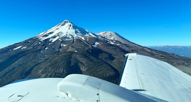
About 25 minutes from Medford was Mount Shasta.  We got exceptional views and by staying upwind the ride was mostly smooth with a bit of  light turbulence.  Flying around the mountains, it is often hard to judge your clearance but our terrain awareness feature highlights any issues.  In the mountains I keep the page up on one of the screens, sort of like watching the weather in the Southeast.

The arrival into Truckee is interesting.  Truckee is at 5,900’ and surrounded by mountains.  They are also very noise sensitive.  They publish extensive procedures and while it is always voluntary, I like to be a good neighbor.  I had studied the local procedures so I knew to begin our approach over the reservoir and followed the highway inbound.  They were using the shorter runway and given the conditions I requested runway 29 which is 7,100’ long.  Tower obliged and had us make a high overhead approach.

We had a nice arrival and ground control explained where to park.  It is a royal pain to push the Baron around so I was keen to find a space where I could pull in straight without having to push the plane around, basically princess parking.  We were lucky, the end row had the first space open and we were soon parked and I had us tied down.  We went to the office and ordered gas and after that got our rental car.  Enterprise is not on the airport but it is only about 300 feet from the door.

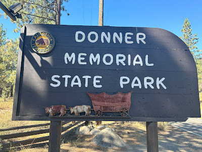
By the time we had the car we drove back to the plane and watched the fueling.  We  paid for the gas and we were ready to roll.  We started at the Donner Party Memorial.  I’m not sure how to feel about a memorial to a group that made a lot of bad decisions and ultimately ate half their party.  My opinion is not shared as they seem to be locally popular as many things are named Donner.  Just to be clear I steered clear of any Doner Kabobs while there....

We grabbed some coffee and then took a drive by the lake.  When we arrived we had not yet seen Lake Tahoe. I thought it would be visible but the view is blocked by a bigmountain.  This geography would figure prominently in our departure but today it was just blocking the view.  We did not do too much at the lake as that was our Sunday activity.  Finishing our lake views, we headed for Reno Nevada.  Yes this is the California stop and we won’t land in Nevada till Monday but we will sightsee both. 


The trip to Reno is quick, only about 35 minutes.  We of course saw the famous sign, cruised the strip and walked through a casino.  The casino was dingy and smokey, it was a sort of sad looking one.  We also did the riverwalk.  The Truckee river flows through town and they have done a nice job making it an attraction.  People were swimming but I tested the water and it was too chilly for me.  There were all sorts of people enjoying the day including one guy who seemed to be meditating in the river.


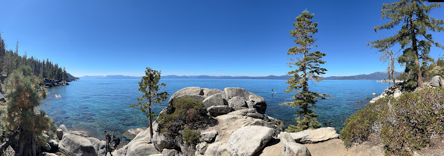
Sunday was Lake Tahoe day.  We decided to circle the lake and see the sights.  Tahoe is stunning, gorgeous, picturesque and more.  That said, it is also crowded and the look of the surrounding towns is dated.  The lake is cold by my standard and the air is thin.  Overall, glad I came to see it but wouldn’t want to live there.  

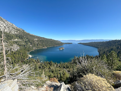
Our first stop was Emerald Cove.  Parking was a nightmare but after some wandering we landed a perfect space with great views.  We did a bit of hiking to see a small waterfall and then headed off to the Nevada side.  Yes the lake is split, about two thirds California and one third Nevada.  This means on one side gas is cheaper and you can gamble. 

We continued around the lake and eventually made our way to Secret Cove and Chimney Beach.  Parking was again an issue but we found a roadside space and started our hike.  It was pretty steep and all down hill.  The beach seems to be so named because there remains a fireplace and chimney from an old cabin.  The cabin is no more.

The views were quite good and we watched people go into the frigid water and even jump from the rocks.  Heading back we had to walk up the very steep trail in the thin air.  The lake surface is 6,225 feet and we had to go up a few hundred feet.  After much huffing, puffing and higher than normal heart rate, we made it back to the car.  We did some more sightseeing before heading off for food and rest.

I see why people like the California mountains.  Blue skies, nice temperatures, mountains, trees, it has it all.  That said, I can’t imagine it in the winter with feet of snow, chains required and the bitter cold.  Tonight I will be reviewing the departure plan. Truckee is at 5,900' feet and even at our light weight with less than full fuel, we will have limited single engine performance.  There is also a lot of terrain and noise sensitive areas to avoid so until we gain some altitude any issues will be critical and we need to be prepared.