
This is a flying vacation but for 3 days the plane was parked. It was time to get in the air again. The first question was how to leave Sedona. Sedona has one runway and it is on a pretty good slope. Normally we depart into the wind but the slope is great enough that if it is not too strong, it is better to take off downhill.

I had been watching the wind it had been strong from the North suggesting an uphill take off but in the early morning things had calmed down quite a bit. As we started the engine, the wind was a bit shifty but when I reached the the main taxiway, it was pretty light so I elected a slightly downwind and downhill departure. The pilot behind me made the same choice, not that it means anything, we both could have been fools. It was a good choice though, the slope is strong (like the force) and we were airborne quickly and climbing out over the buttes.

Since we were still in the mountains, we went VFR. We had clear blue skies so weather was not really a factor. The winds were about 25 knots at altitude so we expected some turbulence in the rougher terrain but it was mostly smooth. We were going to Page Arizona but first we would overfly the Grand Canyon.

The Canyon has special flight rules. Special Federal Aviation Regulation No. 50-2—Special Flight Rules in the Vicinity of the Grand Canyon National Park, AZ to be exact. There are two reasons. They have most areas as flight free to maintain the quiet. They also want to separate the tour operators from other general aviation operations.

There are designated corridors and altitudes for overflight. I had picked up flight following out of Sedona so nearing the Canyon, the controller asked if I was familiar with the rules. I replied wI would fly Fossil North, Dragon South and Zunni North. He seemed satisfied and left us alone to sight see

The flight over the Canyon has great views. I actually liked it more than the park visit. We did have to contend with some smoke. There is a fire on the North rim right now. There were actually flight restrictions to allow firefighting but our altitudes kept us above the fray.

I had intended to land in the Canyon, most places it is a violation but there are a few where it is allowed by following the special procedures. As we headed North, I checked the Page weather and the winds were strong and gusty. I decided to skip that stop today, we had another flight scheduled in the morning and the forecast was for calm winds.

Inbound to page we overflew Horseshoe Bend, one of the reasons we came. We also started to see lots of tour plan traffic. Watching for planes and planning our arrival kept me pretty busy but soon the wheel were down and we were taxiing in. We were met by a golf cart trying to attract our business. There are several operators here so we had choices.

I had already chosen American Aviation. All of the choices were pretty close together but American is in the main terminal building with the Avis desk. I did not bother to have them pull the car on the ramp because it is so close. Our golf cart had lead us to a space. It was pretty far out because they are fixing the ramp.

I had also picked American because they had good reviews. True to the reviews our golf cart driver, helped secure the plane and then drove us to the terminal. Avis had our car and the Avis representative brought it to the curb in front of the entrance. Great service!

Our first stop was Glenn Canyon Dam. The Dam was built in the 60's to create Lake Powell and assure a water supply for the Western States. The Dam offers tours but they must be booked same day, in person. They just run a few a day and only 20 slots per tour. Given our warning that the crowds would be terrible we wanted to maximize our chance for a slot.


Luck was on our side and we snagged 2 slots on the 1:30 tour, you had to return by 1:10 though or risk losing your slot. We took the extra time to enjoy the views of the Dam and Bridge from several vantage points. We also checked into our hotel and headed into town for lunch. Page is small and none of these stops were more than 10 minutes apart.

We arrived on at 1:00 and looked at the museum exhibits and checked in right on time. We had to pay for the tour $5, which is a bargain. Even though it is federally run, it is the Bureau of Reclamation and they don't honor our NPS annual pass.

The tour starts by going through security. The Dam holds all the water for the Western states so they want it keep it in good shape. After security our guide began the tour. You can take pictures of anything and they will answer any question about the Dam except about the security.
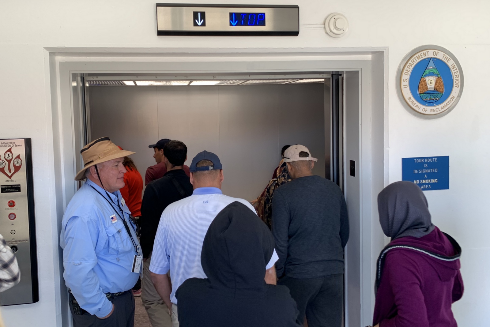
You first an elevator from the visitor center down to the top of the Dam. Here we learned the history and got to walk along the top and take pictures of both the drop and the reservoir.


Our next ride was another elevator from the top to the base of the Dam. It is over 500 feet down. We walked through the base of the Dam to the power generation house were we could see the turbines in action. The turbines get replaced every 40-50 years. They had recently finished replacing all of the turbines a few years back. One of the originals has been left at the Dam top for the tourists to see or maybe because someone got lazy.


This was the end of the tour and we rode the elevators back to the visitor center and headed off to Horseshoe Bend. Horseshoe Bend was what got me thinking about Page. If you have ATT cable, they have a screen saver function when the cable box sits idle. One of the pictures is Horseshoe bend. It looked cool so I wanted to see it in person.

Horseshoe Bend is a tight turn on the Colorado river with great views. A few years back it was a sleepy spot. You parked on the dirt and hiked in. Somehow it became a viral sensation and now it is crazy busy. The town built a big lot and collects $10 per car to visit. The fee started about a year ago so we just missed seeing it for free.

I was a bit miffed that they monetized it but to be fair, it looks like they are using the money to improve the site. The lot is big and paved. They have bathrooms and they are improving the path from the lot to the view. By the end of the visit I was satisfied with the new arrangement.

The need for the lot may have been driven by the hoards of larger tours. Throughout our trip we ran into large tour groups, many from outside the USA. It is about a half mile hike to get to the view. We hiked on in and took a bunch of pictures.

Now we are very respectful of the edge, it can be a long way down at some of these locations. I am amazed at how many people think that it is a good idea to back up to a shear drop of 1000 feet or more on uneven terrain to get a picture or selfy. What really amazes me is that more of them don't go over the edge.


As I said before everything in Page is pretty close. Our Courtyard was half mile from downtown and everything else was less than 10 miles away, including Utah.
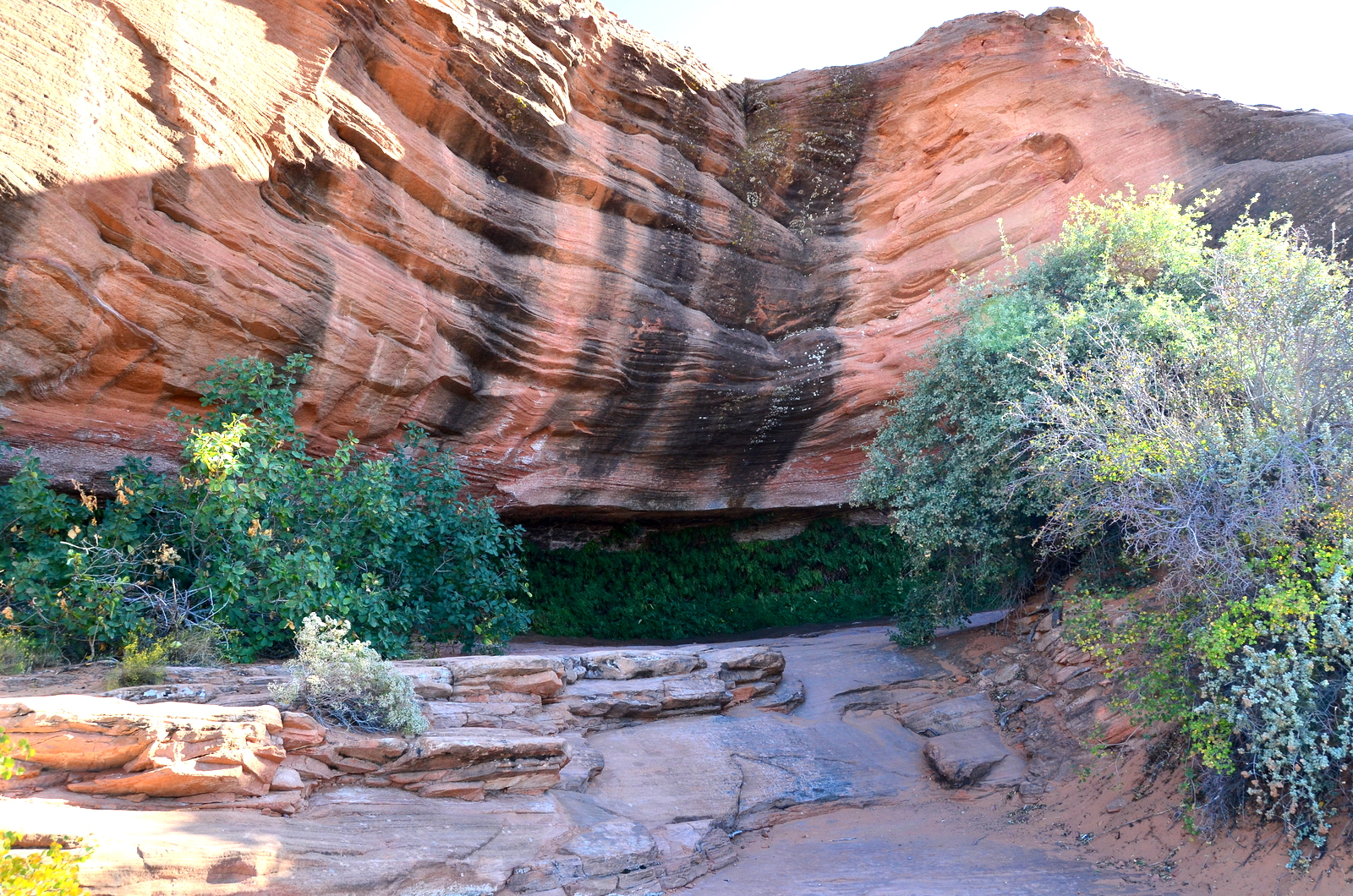
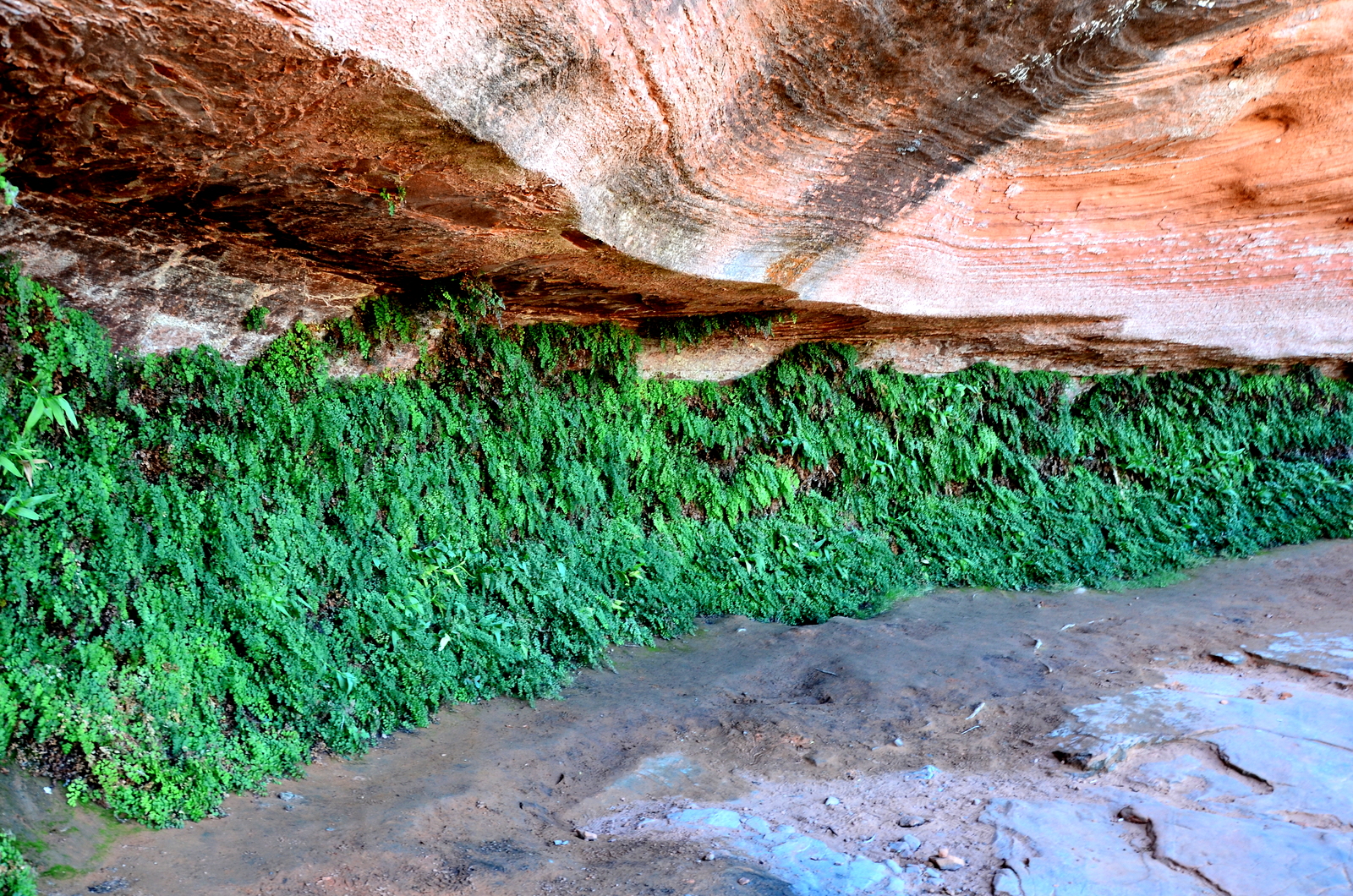
We still had time before sunset so we headed to the Hanging Garden Trail head. At the trail end you are rewarded with a rock overhang that has plants growing across the vertical wall. I believe it is a pretty unique formation and just has the right amount of moisture and light.

We enjoyed the walk and the hanging greenery. The trail has an additional side trail that takes you to the top of a small rock hill. It had good views of the surrounding area, including Lake Powell. The sun was starting to head down so we called it a day and headed for the hotel.

No comments:
Post a Comment