
As I write this, the storms are rumbling through. The forecast had them coming a bit later but this was the same forecast that said there would be no storms on the way home from Dothan Alabama, yeah right. I had to run over to Dothan this morning and other than some early fog it looked to be a pretty easy flight. I launched just before 000 and made a quick stop at Suwannee for the cheap gas, then on to Dothan.

Departing Dothan I was given a climb to 9000 and cleared direct home. The trip over had been mostly clear skies with the rain well South by the Gulf. I was not expecting anything on the way back as I had looked at the radar and was not on the ground long but climbing out, there was a line forming just South of my route. It did not look like an issue until about 10 minutes later when the controller informed me the MOA (Military Operations Area) was now in use.

The MOA is the Purple blob blocking my route. The controller wanted to send me the long way around the North but I was not keen to burn the extra gas. Also it was not clear whether it might fill in and trap me North of my destination. I asked about the Southern route and was given direct Greenville VOR (GEF) then direct. Oh and btw, let us know when you want to start deviating. As you can see the clearance was going to take me through the storms.

I was actually in great weather and above most of the low stuff so I fired up the radar and started planning. The turn at GEF would keep me clear of the rain by the Gulf, then I just needed to work past that long line on the Georgia Florida border.

Making my turn at GEF I could see the buildups, they were actually pretty scattered. The big cloud chimneys looked imposing but between the radar and my eyes I was able to chart a path down the valleys between the cloud cliffs.
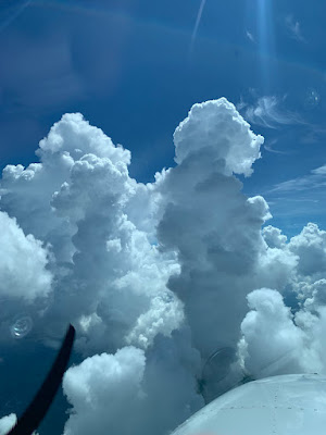
Things were changing quickly and I could actually see the clouds boiling up. While today I mostly relied on my eyes, the onboard radar confirmed my path while the satellite radar was quite misleading. For example, I ended up sliding between two strong rain shafts near Lake City. The tops were only in the low teens and at 9000 I was above all but the cores. Notice that the XM weather is not really showing the quickly forming intense rain nor that pillar of rain at 18 miles that will be just off to my right.


If the rain had been more developed and more vertical, I would have given it much more room. I did expect a bit more turbulence but by staying out of the buildups, I had a very smooth ride.

After Lake city I just had one small area of storms to avoid but by this time I was descending and could no longer pick my way visually. Again the live radar showed a lot more than the XM.


I skirted South of the last rain showers and broke out around 3000. There was a slow Cessna on the ILS to 32, they were using 23 though but because of the opposite direction traffic, I was going to be vectored around quite a bit. I don't like cancelling but sometimes it makes everything easy. I cancelled, the controller handed me to tower and in I went.

They were using 23 but the winds were calm and I was set up for 14 so I asked and was given 14 with a land and hold short of 23. This worked well and I joined the right base and soon was rolling to a stop on 14. The controller had given me full length on final but I easily made the 2000' turn off and the plane was soon away in the hangar.
No comments:
Post a Comment