Tuesday, September 22, 2020

West Virginia Mountain Momma

Saturday was crisp and clear.  The sky was dark blue and the temperature overnight dropped to 40.  We headed out early for us to sample the great outdoors.  For those new readers, you may have noticed that the last post had West Virginia as state 28.  Back in 2017 I decided to land in all of the lower 48 states.  I reset my total to 48 and have been counting down since. 


We had sampled some small roads on Friday.  I am used to driving through the rural Southeast but generally you get a line on the road.  On Friday we had a few places with no line.  Today we would take this up a notch as we wound our way  across North Eastern West Virginia and Maryland.

Rachel and Sam have Switches and we have been playing family Mario Cart as part of our quarantine activities.  Nothing builds family bonds like knocking a member off the track or zapping them with a power up.  I found that this was good training for the roads we drove.  We went from 2 lane winding, to blank pavement, to not wide enough for two cars.  This theme was present Sunday as well.


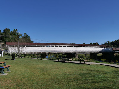
Our first stop was at historic Philippi to see the covered bridge.  We did more than see it though, we drove through it.  When we stopped, there was a memorial at the bridge.  It was to the coal miners that lost their lives.  A reminder that this is a coal state and mining is a dangerous business.  The mines are not visible but you do see random piles of coal lying around.


After enjoying the Bridge views, we headed off to Douglas falls.  Douglas falls are just outside Thomas, WV.  The main attraction is Blackwater falls but that was next.  Passing through Douglas, it reminded us of Jerome, AZ.  Both had mining connections and both built on a hill with two main streets, both one way with quaint shops.  We avoided the shops this trip but normally would have been a fun stroll.


On the way we saw some more Windmills.  We had seen a bunch the day before and would continue to see them.  Sort of ironic, all those spinning blades had to drive home the point that coal was on the way out.


Getting to the falls is a bit tricky.  you follow city streets and find the tiny sign pointing down a dirt road.  Then you head down that road for about a mile.  At a few points it  had standing water and some serious ruts.  The ruts were not big enough to swallow a Tahoe but we had a rental Kia so we had to be careful.


At the end of the dirt road there was a sort of parking area and a gate saying no motorized traffic.  We parked and started walking down the path.  We ran into a group of hunters. We had seen a lot of them on the way.  Big trucks, groups of dogs, guns, and orange vests.  They confirmed we were indeed walking the correct direction and the rushing water gave us confidence.

Getting down to the falls was a short but it was a steep and rocky 40 foot descent.  It was well worth it, they are some nice looking falls and there were just a handful of people around the entire visit so distance was not an issue.


We worked our way back to the car and then headed off to Blackwater Falls.  The car was undamaged but it did have a thick coat of dirt.  Somehow our adventures always end with dusty rental cars.  Blackwater falls are just a few miles away on the other side of town so it was a quick trip.  This is a proper state park and it was much busier.  This was probably the most trouble we had staying away from people.


Blackwater is an impressive fall and they have very nice stairs, walkways and viewing platforms.  We enjoyed the views while shifting as needed to stay distant and then headed off.  I had read that there was a second view from the opposite side of the river so we went in search because water looks different from the other side.


After a short drive we found a parking lot and figured we were at least close to the right place.  After we were parked we saw a sign that was visible when travelling the other way that said we had found the overlook.  This one was made for people who needed a flat surface to access the falls.  We walked a short path and got another nice view of the falls.


Our stops so far had been fun but were not strenuous, our step count was till low.  We decided to head back to Douglas and take a walk on the Blackwater Canyon trail by the river.  I took the drone with me and got some nice shots of the town and dam.  I had flown it Friday at a park in the town but they are generally not allowed in state and federal parks so it had stayed in the car all morning.


We were getting hungry so we packed up and drove up to Oakland, Maryland.  It was on the way to Swallow Creek State Park and had lots of choices yet we settled on DQ and ate lunch as we approached the park.  As we entered the Park we found our first traffic jam.  There were about 20-30 cars ahead of us.


We were a bit concerned it would be crowded but we patiently waited and soon were paying the ranger.  As we waited a good many cars left and when we entered there was no issue scoring a prime spot by the trail head.

This park has three waterfalls but the first (Toliver) is more of a dribble.  The Swallow Creek falls both Upper and Lower are nice as are the Muddy Creek falls.  The trails were pretty busy and you do have moments when you get closer to people but generally we were able to do our own thing and enjoy the trail and the water.


When it was time to leave, there wasn't a car heading in.  In fact I think we must have hit a weird rush as the park was busy but not full. The park does have a camping section so maybe everyone was heading there.  Camping is not our thing so we were definitely not competing with them.


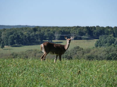
On the way back I had to choose between the scenic route and the fastest route.  I chose scenic and it paid off.  coming down a small road we saw 3 deer grazing and got some nice pictures.  Deer are not an odd site but mid afternoon in the open and unafraid of us seemed odd.  We did all our pictures from the car lest they decided to come have a conversation with us.


Our Dinner was KFC which while tasty annoyed me.  First they tried to give us someone else's order and then they shorted my 3 piece chicken and gave me a 2 piece.  Luckily I believe this is the worst tragedy the we personally faced on the trip.

Monday, September 21, 2020

Vacation time (#28 West Virginia)


COVID has impacted our travels.  Early on we cancelled a trip as things were locking down.  Then the summer was super hot and crowded.  With the kids returning to virtual school and the weather changing, we decided it was time to travel.  So where to go?  I decided we would do a hiking weekend.  


West Virginia was still on the list of states to visit and with lots of nature, picked Clarksburg.  Why Clarksburg?  I wanted to be further North where it was cooler, wanted the mountains and it has a good airport with Hertz cars.

All week we watched Hurricane Sandy progress and I wondered if she would clear in time.  The rains did but the clouds persisted and early Friday when I awoke, the weather was a bit lower than I like.  I did the only reasonable thing, reset the alarm and went back to sleep.  An hour later the sun was higher and our path was looking better.


Direct to Clarksburg takes you right over Charlotte.  I knew that was not gonna happen as the last thing they want in their flow is a slow piston plane clogging the airspace.  So I had to decide East or West of Charlotte.  I had planned both and the weather made the decision.  Sunny on the West and low clouds on the East.  We went West.  Our fuel stop was Shelby county and the ride up was good with the exception of 20 knot headwinds.  


I had planned to cut over the mountains around Roanoke, VA but the clouds were low.  At Shelby I refiled a route North and then cut over to Clarksburg on the North side of the mountains.  Shelby was clear and we had been watching Clarksburg all morning.  It had gone up to 1200' and then back to 600' overcast.  Minimums were 590 for the straight in approach from the South so I was making plans as to how to handle a potential missed approach.


Luckily as we approached the clouds lifted to 1300' and the approach was bumpy and wet but pretty easy.  The runway appeared and we were soon parked at the FBO.  We got the prime spot, right by the dumpster.  It worried me a bit but the plane was fine.


They had our Hertz car waiting and we were off to sightsee.   Our first official stop was Arbys.  Practicing safe travelling we avoided inside dining and did takeout, drive through or curbside.  Once fed we headed further North and crossed into Pennsylvania to see Cucumber falls.  The falls were an easy hike and we continued down to the river to see some rapids.


Our next stop was just a few minutes away,  Ohiopyle, PA.  The small town is known for its bridge, its rapids and its ice cream.  It is a quaint town.  After taking in the water features we sampled the ice cream.


Our final stop was Cooper State park in WV.  It is known for its overlook.  It is a nice view and it has a short underlook trail which we completed.  The sun was setting and it was getting dark so we headed back to our hotel.  Dinner was Taco Bell.  I noticed on Google Maps that it is listed as a "Mexican inspired fast food chain".  I think that is a good description.  Not Mexican food but very inspired.


A few words on travelling during COVID.  We did a few things different.  I booked Towneplace Suites because I wanted the fridge and dining table as we would be eating in the room.  We took drinks and snacks with us to avoid one extra grocery trip.  I also packed a COVID kit with the essentials; masks, gloves, wipes and sanitizer.  We used little of the kit but it was good to know we were prepared.


Overall WV seems to be ignoring COVID at the personal level.  Only about 20% mask usage and some people tried to get in our space at the parks.  We just smiled and adjusted to keep our distance.  Overall without having to use commercial air transport, travel was easy and either contactless or socially distant throughout.


You will see our food choices were not great but to be fair, there were not great restaurants in Clarksburg that I felt I missed.


Sunday, August 16, 2020

The coming storm

Saturday I awoke to clear skies but when I started looking at the weather, the picture was not so rosy.  There was a line of rain from the Florida/Georgia border to the West Coast North of Tampa.


You can see how nice it looked if you looked the right way.  Holding short for takeoff I could see what was coming.  Regardless the storms were actually moving quite slowly so I decided to go out for a morning flight before the rain.


On departure I had a good preview of the rain.


It was still Sunny downtown and listening to approach, I could hear them still skydiving over at Herlong.


I headed South West parallel to the rain to have a better look.  It made quite a nice picture on the GPS.


I could see the rain showers under the storm front but stayed well clear.


It made for some nice scenery as I worked my way back North East.


JAX was still in the sun too and I got a nice overhead view.


Fernandina was also quite with the ship cutting frames still hanging out.  I guess the ship at Saint Simons is not yet ready to be cut.


I returned before any of the rain started.  I did drop by Safe Harbor for fresh fish and saw lightning in the distance returning to the car.  The storm line sort broke up so the coming storm never really came though we got some sprinkles at the house.  I did see the airport has a new system to mow the grass.  This poor guy was working alone on the weekend.


Sunday, August 2, 2020

Hurricane Hunter

We are under a Tropical Storm warning.  Should have rain later today but this morning the sky was blue.


NOAA flies into Hurricanes, I fly near Hurricanes.  When I looked at the weather I could see the main outer band was around Daytona.  There was also a bit of rain over Saint Augustine.  My gut said that it would be building rapidly.


Departing, it was pretty blue.  I quickly climbed over the few clouds.  Originally I was thinking 6500 would keep me on top but later decided 8500 would provide more room.


As I headed South, it looked like I could slide between the rain over St. Augustine.  There were some big holes but I decide to stay to the West where I always had an escape route.


I slid by the close rain but my real target was the big storm.   You can see the storms over St. Augustine were starting to get denser.


Once I cleared the first line, I got a good look ahead.  I had ended up going further West than I initially planned so I had called Jacksonville Approach to confirm the restricted areas over by lake George were cold.  They were and I decided to head for over the lake.


This is the leading mass of the storm.  Pretty sure we will get some of this rain later today.  Oddly it was lots of rain but not much lightning.  I was watching the various displays and my lightning detector.  It was much quieter than I had expected.


I took a panorama view as well as the GPS display with all the pretty colors.  Even without lightning and the storms not being that tall, I was giving them the respect they deserved and keeping my distance, about 30 nautical miles.


This is lake George, it was a nice day when I was there.  Expecting it to deteriorate a bit.


I had seen the storm and now it was time to head back.  The rain had built over Saint Augustine and the clouds were thicker the entire way back.  This is the back side of the leading line.


I had thought ahead and filed an IFR plan just in case.  I requested it from JAX once I was in a position to go direct home without getting too close to the storms.


I was cleared down to 6000 and direct home.  This was the picture ahead, you can see the junk on the right.


Nice smooth air for the ride home and I could see the rain off to my right.


Why the IFR?  It was 2500 bases and not that dense so I could have stayed VFR.  Well it is just easier and sort of fun to zip through the clouds rather than stressing about finding a legal hole and having to detour.  Here I got to fly through a cloud tunnel.


Bases were 2500 so I was soon underneath with the field in sight.  I was transferred to tower and made a nice landing on 5.  Spent some time cleaning the hangar and now plane is away and safe from the approaching rain.


Saturday, July 18, 2020

Trapped on top

We left this morning for some sightseeing.  We still are holding off on travel so we planned a round robin flight over Gainesville Florida.  On departure we had scattered clouds but heading Southwest they were quickly thickening.  I found a big hole and was soon on top but our planned cruise at 4500 was not working.  The clouds were building.


We stepped up to 6500 and eventually to 8500 and then 9500 when we headed Northeast.  We have to stay 500' below, 1000' above and 2000' lateral from clouds when visual.  By climbing and maneuvering we kept the required distances as we headed to Gainesville.  Turning back Northeast we couldn't see a clean path home so we headed more Northerly where the clouds were lower.

We had picked up visual flight following halfway to Gainesville as the clouds had us divert over some restricted airspace and we needed to confirm that it was not in use and that we were allowed to pass through.  We were above the clouds but eventually we needed to get below while following the rules.  Seeing the clouds build, we discussed our options to get home safely and legally. 


We had 4  options.  Home was reporting scattered clouds so option 1 was stay on top, climb as needed to get back home and then spiral down.  Option 2 was to spiral down near Gainesville where the clouds were not very dense and fly below on the way home.  Option 3 was to maneuver between the clouds and find a path home much like we had found our way to Gainesville, the danger was finding a dead end and having to backtrack or climb again.  Option 4 was to pick up an IFR clearance and then just go through the clouds.


Options 1 and 2 were not efficient and option 1 had the chance of becoming option 4 anyway.  We started with option 3 and flew North about 5 minutes.  Looking towards home it became increasingly clear it was gonna be hard or impossible to make it work.  This is where being instrument equipped and proficient is so handy.  I requested an instrument clearance and was given it right away.  After that we were cleared for our descent and slid through a few clouds as we were vectored home.


So was it bad planning on my part, well the forecast was for scattered clouds only.  The bases were right around 3000 so we could have easily just spiraled down and then proceeded home down low in the heat and bumps burning extra gas.  For us today it was all comfort and efficiency.  We had many safe options.  For a visual only pilot, getting stuck among building clouds can be an emergency so it is best not to get yourself into a situation where you may have trouble getting out.

Saturday, June 27, 2020

Sahara dust

It was oil change time.  I like doing my oil changes, typically 4 per year.  One always falls mid summer and that's the one I don't like as much.  Too hot.  So Friday end of day I went out and warmed the oil and started the draining process.  I say process because the filter sits vertically facing down.  If you want to go fast you can put rags under the filter to catch the drips.  If you are patient and let all the oil drain, you don't have any drips.


So Friday was warm and drain, Saturday I awoke early to finish the job before it got too hot.  The change went smoothly, without any drips.  The filter was clean when I inspected it so all was good.  You do a run after the change to check for leaks and that was a success as well.  I like to do a quick flight as well to just make sure before I venture out on a longer flight.  The visibility was reported at 7-10 but it looked much worse.


Taking off I was in a haze bowl.  Turning to the beach I had to go a few miles before the coast was visible.  Turning towards the airport at 8 miles out I could not see the airport.  It started to appear at 6 miles and was clear at 5.  I suggested to the tower that they may want to turn on the runway lights.  I know I saw the airport partially because I knew where to look.  Transient students would have a tougher time and the lights would help a lot.


I have 15 minutes flight time this weekend and unless it clears a bit that may be all I do.